
File:China-Heilongjiang.png
此为最大尺寸。
China-Heilongjiang.png (268 × 218像素,文件大小:31 KB,MIME类型:image/png)

|
File:China Heilongjiang.svg是此文件的矢量版本。 如果此文件质量不低于原点阵图,就应该将这个PNG格式文件替换为此文件。
File:China-Heilongjiang.png → File:China Heilongjiang.svg
更多信息请参阅Help:SVG/zh。 |
 |
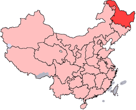
en: Location of Heilongjiang Province in the People's Republic of China. See Locator maps of province-level divisions of the People's Republic of China for more information. The striped area is administered by Daxing'anling Prefecture of Heilongjiang, but it is nominally part of Inner Mongolia Autonomous Region.
zh: 黑龍江省在中華人民共和國的位置。另見Locator maps of province-level divisions of the People's Republic of China。加斜杠的地區由黑龍江省大興安嶺地區所管轄,但在名義上為内蒙古自治區的一部分。

|
已授权您依据自由软件基金会发行的无固定段落及封面封底文字(Invariant Sections, Front-Cover Texts, and Back-Cover Texts)的GNU自由文件许可协议1.2版或任意后续版本的条款,复制、传播和/或修改本文件。该协议的副本请见“GNU Free Documentation License”。 |
| 本文件采用知识共享署名-相同方式共享 3.0 未本地化版本许可协议授权。 | ||
| ||
| 本许可协议标签作为GFDL许可协议更新的组成部分被添加至本文件。 |
文件历史
点击某个日期/时间查看对应时刻的文件。
| 日期/时间 | 缩略图 | 大小 | 用户 | 备注 | |
|---|---|---|---|---|---|
| 当前 | 2007年10月28日 (日) 14:45 | | 268 × 218(31 KB) | Croquant | transparent background |
| 2005年6月4日 (六) 21:47 |  | 268 × 218(9 KB) | Ran | '''en''': Location of Heilongjiang Province in the People's Republic of China. See Category:Locator maps of province-level divisions of the People's Republic of China for more information. The striped area is administered by Daxing'anling Prefecture |
文件用途
没有页面链接到本图像。
全域文件用途
以下其他wiki使用此文件:
- cy.wikipedia.org上的用途
- da.wikipedia.org上的用途
- de.wikipedia.org上的用途
- en.wikipedia.org上的用途
- Pingfang, Harbin
- Wikipedia:WikiProject Chinese provinces/Locator maps
- Songjiang Province
- Longjiang County
- Jingpo Lake
- Wanda Mountains
- Mingshui County
- Heitai
- Kedong County
- Bei'an
- Nan'gang, Harbin
- Yabuli Ski Resort
- Ang'angxi District
- Diaoshuilou Falls
- Mudan River
- Zhalong Nature Reserve
- Nenjiang Province
- Gannan County
- Nehe
- Shuangcheng, Harbin
- Tangchi, Heilongjiang
- Tieli
- Mishan
- Baoquan, Heilongjiang
- Heihe Aihui Airport
- Yi'an Town, Heilongjiang
- Laha, Heilongjiang
- Muling
- Template:Heilongjiang-geo-stub
- Daxing'anling Prefecture
- Daoli, Harbin
- HLA-B67
- HLA-B59
查看此文件的更多全域用途。