
File:CopánMap.jpg
此为最大尺寸。
CopánMap.jpg (300 × 266像素,文件大小:51 KB,MIME类型:image/jpeg)
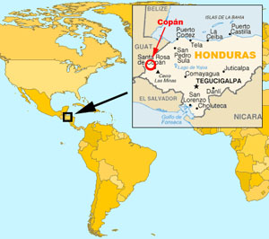
Location of Copán, Honduras. Free maps from www.planiglobe.com [1] and www.cia.gov [2] archive copy at the Wayback Machine. Montage from El Comandante.
本文件采用知识共享署名-相同方式共享 2.0 通用许可协议授权。
- 您可以自由地:
- 共享 – 复制、发行并传播本作品
- 修改 – 改编作品
- 惟须遵守下列条件:
- 署名 – 您必须对作品进行署名,提供授权条款的链接,并说明是否对原始内容进行了更改。您可以用任何合理的方式来署名,但不得以任何方式表明许可人认可您或您的使用。
- 相同方式共享 – 如果您再混合、转换或者基于本作品进行创作,您必须以与原先许可协议相同或相兼容的许可协议分发您贡献的作品。
Planiglobe license:
| This image is from Planiglobe. All maps hosted on Planiglobe are licensed under the Creative Commons Attribution 2.5 License, but Planiglobe suggests that they not be used for navigational purposes. For the purposes of this license, this clause is considered a disclaimer and not a license restriction. |
文件历史
点击某个日期/时间查看对应时刻的文件。
| 日期/时间 | 缩略图 | 大小 | 用户 | 备注 | |
|---|---|---|---|---|---|
| 当前 | 2005年4月2日 (六) 04:48 | | 300 × 266(51 KB) | El Comandante | Location of Copán, Honduras. |
文件用途
没有页面链接到本图像。
全域文件用途
以下其他wiki使用此文件: