
File:CraterHighlands Tanzania NASA.jpg
本预览的尺寸:484 × 600像素。 其他分辨率:194 × 240像素 | 540 × 669像素。
原始文件 (540 × 669像素,文件大小:118 KB,MIME类型:image/jpeg)
摘要
| 描述 |
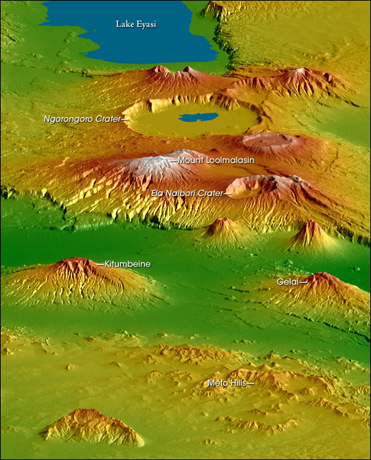
English: Topographical map of the w:Crater Highlands in Tanzania. Color indicates height, with lowest elevations in green and highest elevations in white. Shading shows the slope. The vertical relief has been exaggerated by a factor of 2 to reveal greater detail about the landscape. The image is oriented as though you were looking from the north toward the southwest.
Afrikaans: Topografiese kaart van Tanzanië se kraterhooglande. Kleur dui hoogte aan, met laagste gebiede in groen en hoogste hoogtes in wit. Skadu dui hellings aan, en die vertikale reliëf is verdubbel om meer landskapdetail weer te gee. Die uitsig is georiënteer van die noordooste na suidweste. Natronmeer is net buite sig aan regterhand. |
| 日期 | |
| 来源 | https://earthobservatory.nasa.gov/IOTD/view.php?id=6316 |
| 作者 | Robert E. Crippen, NASA/JPL Shuttle Radar Topography Mission team. Labels by NASA Earth Observatory newsroom. |
| 授权 (二次使用本文件) |
US government, public domain. |
| 其他版本 | Larger, unannotated version available at source URL. |
许可协议
| 本文件完全由NASA创作,在美国属于公有领域。根据NASA的版权方针,NASA的材料除非另有声明否则不受版权保护。(参见Template:PD-USGov/zh、NASA版权方针页面或JPL图片使用方针。) | ||
 |
警告:
|
文件历史
点击某个日期/时间查看对应时刻的文件。
| 日期/时间 | 缩略图 | 大小 | 用户 | 备注 | |
|---|---|---|---|---|---|
| 当前 | 2006年4月28日 (五) 17:53 | | 540 × 669(118 KB) | Holly Cheng | {{Information | Description=Topographical map of the w:Crater Highlands in Tanzania. Color indicates height, with lowest elevations in green and highest elevations in white. Shading shows the slope. The vertical relief has been exaggerated by a factor |
文件用途
全域文件用途
以下其他wiki使用此文件:
- arz.wikipedia.org上的用途
- avk.wikipedia.org上的用途
- ceb.wikipedia.org上的用途
- de.wikipedia.org上的用途
- el.wikipedia.org上的用途
- en.wikipedia.org上的用途
- es.wikipedia.org上的用途
- fr.wikipedia.org上的用途
- he.wikipedia.org上的用途
- hr.wikipedia.org上的用途
- ru.wikipedia.org上的用途
- sh.wikipedia.org上的用途
- sl.wikipedia.org上的用途
- sr.wikipedia.org上的用途
- sw.wikipedia.org上的用途
- uk.wikipedia.org上的用途
- www.wikidata.org上的用途