
File:Drygalski-Fjord-Map.png

本预览的尺寸:800 × 458像素。 其他分辨率:320 × 183像素 | 640 × 366像素 | 1,139 × 652像素。
原始文件 (1,139 × 652像素,文件大小:153 KB,MIME类型:image/png)
文件历史
点击某个日期/时间查看对应时刻的文件。
| 日期/时间 | 缩略图 | 大小 | 用户 | 备注 | |
|---|---|---|---|---|---|
| 当前 | 2024年1月8日 (一) 21:14 | | 1,139 × 652(153 KB) | Apcbg | added detail |
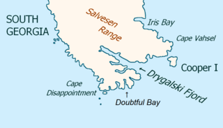
| 2007年11月19日 (一) 13:34 |  | 1,139 × 652(2.13 MB) | Apcbg | == Summary == {{Information |Description=Map of Drygalski Fjord, South Georgia Island |Source=self-made |Date=4 October 2007 |Author= Apcbg }} == Licensing == {{PD-self}} | |
| 2007年11月19日 (一) 13:27 |  | 1,190 × 684(2.33 MB) | Apcbg | == Summary == {{Information |Description=Map of Drygalski Fjord, South Georgia Island |Source=self-made |Date=19 November 2007 |Author= Apcbg }} == Licensing == {{PD-self}} | |
| 2007年11月19日 (一) 13:19 |  | 1,190 × 684(2.33 MB) | Apcbg | == Summary == {{Information |Description=Map of Drygalski Fjord, South Georgia Island |Source=self-made |Date=4 October 2007 |Author= Apcbg }} == Licensing == {{PD-self}} | |
| 2007年11月19日 (一) 13:08 |  | 1,190 × 684(2.33 MB) | Apcbg | == Summary == {{Information |Description=Map of Drygalski Fjord, South Georgia Island |Source=self-made |Date=19 November 2007 |Author= Apcbg }} == Licensing == {{PD-self}} | |
| 2007年10月4日 (四) 20:42 |  | 1,190 × 684(2.33 MB) | Apcbg | == Summary == {{Information |Description=Map of Drygalski Fjord, South Georgia Island |Source=self-made |Date=4 October 2007 |Author= Apcbg }} == Licensing == {{PD-self}} |
文件用途
全域文件用途
以下其他wiki使用此文件:
- ang.wikipedia.org上的用途
- bg.wikipedia.org上的用途
- de.wikipedia.org上的用途
- en.wikipedia.org上的用途
- es.wikipedia.org上的用途
- fa.wikipedia.org上的用途
- fr.wikipedia.org上的用途
- he.wikipedia.org上的用途
- it.wikipedia.org上的用途
- ja.wikipedia.org上的用途
- nl.wikipedia.org上的用途
- nn.wikipedia.org上的用途
- no.wikipedia.org上的用途
- pt.wikipedia.org上的用途
- ru.wikipedia.org上的用途
- uk.wikipedia.org上的用途