
File:Escadre allemande d'Extrême-Orient 1914 1915-de.svg

此SVG文件的PNG预览的大小:800 × 413像素。 其他分辨率:320 × 165像素 | 640 × 330像素 | 1,024 × 529像素 | 1,280 × 661像素 | 2,560 × 1,321像素 | 3,100 × 1,600像素。
原始文件 (SVG文件,尺寸为3,100 × 1,600像素,文件大小:1.12 MB)
摘要
| 描述 |
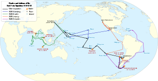
Deutsch: Routen, Stationen und Seegefechten des Ostasiengeschwaders von Juni 1914 bis März 1915. English: Routes, stations and battles of the German East Asia Squadron from June 1914 to March 1915. Français : Routes, étapes et batailles de l'escadre d'Extrême-Orient entre juin 1914 et mars 1915. |
| 日期 | |
| 来源 |
本檔案衍生自:
|
| 作者 | |
| 其他版本 | |
| SVG开发 |
_(180E).svg)
许可协议
我,本作品著作权人,特此采用以下许可协议发表本作品:
| 非营利著作权:本艺术作品是自由的,您可以依据自由艺术作品许可协议的条款传播和/或修改本艺术作品。您可以在Copyleft Attitude网站或其他网站找到该许可协议的样本。 |
This file is licensed under the Creative Commons Attribution-Share Alike Attribution-Share Alike 4.0 International, 3.0 Unported, 2.5 Generic, 2.0 Generic and 1.0 Generic license.
- 您可以自由地:
- 共享 – 复制、发行并传播本作品
- 修改 – 改编作品
- 惟须遵守下列条件:
- 署名 – 您必须对作品进行署名,提供授权条款的链接,并说明是否对原始内容进行了更改。您可以用任何合理的方式来署名,但不得以任何方式表明许可人认可您或您的使用。
- 相同方式共享 – 如果您再混合、转换或者基于本作品进行创作,您必须以与原先许可协议相同或相兼容的许可协议分发您贡献的作品。
您可以选择您需要的许可协议。
原始上传日志
This image is a derivative work of the following images:
- Ostasiengeschwader 1914-15.png licensed with Cc-by-sa-3.0, Cc-by-sa-3.0-de, GFDL
- 2011-09-12T01:44:02Z File Upload Bot (Magnus Manske) 2000x1488 (406202 Bytes) {{BotMoveToCommons|de.wikipedia|year={{subst:CURRENTYEAR}}|month={{subst:CURRENTMONTHNAME}}|day={{subst:CURRENTDAY}}}} {{Information |Description={{de|Routen und Stationen des Ostasiengeschwaders von August 1914 bis März 19
- Cruise of the Emden 1914 Map.png licensed with PD-US
- 2008-11-07T05:20:00Z Rcbutcher 767x548 (94370 Bytes) ''{{Information |Description=Map showing the cruise of German raider, light cruiser SMS Emden in the Indian Ocean September - November 1914.|Source="A History of Sea Power". From Official British Naval History, Vol. I.<br>Downloaded from Project Gu
- Blank map of the world (Robinson projection) (180E).svg licensed with PD-self
- 2011-05-16T02:05:36Z Milenioscuro 3100x1600 (2154098 Bytes) {{Information |Description=A blank map of the world centered at the 180E longitude line. |Source=*[[:File:BlankMap-World-180E.svg|]] |Date=2011-05-16 02:04 (UTC) |Author=*[[:File:BlankMap-World-180E.svg|]]: [[:User:Lokal_Prof
文件历史
点击某个日期/时间查看对应时刻的文件。
| 日期/时间 | 缩略图 | 大小 | 用户 | 备注 | |
|---|---|---|---|---|---|
| 当前 | 2021年1月1日 (五) 19:02 | | 3,100 × 1,600(1.12 MB) | Artoria2e5 | Add language detection hack |
| 2021年1月1日 (五) 18:52 |  | 3,100 × 1,600(1.12 MB) | Artoria2e5 | File uploaded using svgtranslate tool (https://svgtranslate.toolforge.org/). Added translation for en. | |
| 2020年4月6日 (一) 11:36 |  | 3,100 × 1,600(1.11 MB) | Andreas P 15 | File uploaded using svgtranslate tool (https://tools.wmflabs.org/svgtranslate/). Added translation for hu. | |
| 2014年3月11日 (二) 17:40 |  | 3,100 × 1,600(1.08 MB) | Kopiersperre | == {{int:filedesc}} == {{Information |Description= {{Multilingual description |de= Routen, Stationen und Seegefechten des Ostasiengeschwaders von Juni 1914 bis März 1915. |en= Routes, stations and battles of the [[:en:Germa... |
文件用途
没有页面链接到本图像。
全域文件用途
以下其他wiki使用此文件:
- ca.wikipedia.org上的用途
- de.wikipedia.org上的用途
- el.wikipedia.org上的用途
- en.wikipedia.org上的用途
- es.wikipedia.org上的用途
- hu.wikipedia.org上的用途
- it.wikipedia.org上的用途
- nl.wikipedia.org上的用途
- pl.wikipedia.org上的用途
- vi.wikipedia.org上的用途