
File:Europe sunshine hours map.png

本预览的尺寸:655 × 600像素。 其他分辨率:262 × 240像素 | 524 × 480像素 | 839 × 768像素 | 1,119 × 1,024像素 | 1,360 × 1,245像素。
原始文件 (1,360 × 1,245像素,文件大小:97 KB,MIME类型:image/png)
摘要
| 描述 |
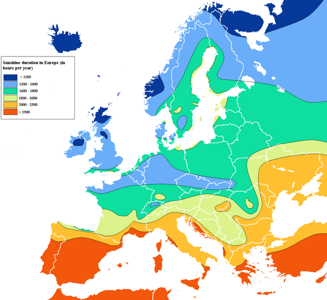
English: Simplified map of sunshine duration in Europe according to national data |
| 日期 | 12/11/2010 |
| 来源 | 自己的作品 |
| 作者 | XL3 |
许可协议
我,本作品著作权人,特此采用以下许可协议发表本作品:
本文件采用知识共享署名-相同方式共享 3.0 未本地化版本许可协议授权。
- 您可以自由地:
- 共享 – 复制、发行并传播本作品
- 修改 – 改编作品
- 惟须遵守下列条件:
- 署名 – 您必须对作品进行署名,提供授权条款的链接,并说明是否对原始内容进行了更改。您可以用任何合理的方式来署名,但不得以任何方式表明许可人认可您或您的使用。
- 相同方式共享 – 如果您再混合、转换或者基于本作品进行创作,您必须以与原先许可协议相同或相兼容的许可协议分发您贡献的作品。

|
已授权您依据自由软件基金会发行的无固定段落及封面封底文字(Invariant Sections, Front-Cover Texts, and Back-Cover Texts)的GNU自由文件许可协议1.2版或任意后续版本的条款,复制、传播和/或修改本文件。该协议的副本请见“GNU Free Documentation License”。 |
您可以选择您需要的许可协议。
文件历史
点击某个日期/时间查看对应时刻的文件。
| 日期/时间 | 缩略图 | 大小 | 用户 | 备注 | |
|---|---|---|---|---|---|
| 当前 | 2023年10月24日 (二) 01:13 | | 1,360 × 1,245(97 KB) | Uness232 | Reverted to version as of 07:25, 25 February 2023 (UTC): Unfortunately still wrong. I appreciate the attempts, but most of the Black Sea is below 2000 hours, which is just not that easy to fix. |
| 2023年8月14日 (一) 16:40 |  | 1,360 × 1,175(774 KB) | Iktsokh | Tried to be as accurate as possible based on your data (I sincerely appreciate your clarifications and corrections, it's important). | |
| 2023年2月25日 (六) 07:25 |  | 1,360 × 1,245(97 KB) | Uness232 | Reverted to version as of 20:37, 20 February 2023 (UTC) Again, I am not happy that I'm reverting this, but the information is still quite wrong. There is a somewhat extensive region (more extensive than the region in Spain anyway) or northern Turkey that should be around 1400-1600. If the Turkish official site is tough to navigate, use the links in the Wikipedia pages Trabzon, Rize, Giresun and Ordu. | |
| 2023年2月21日 (二) 14:21 |  | 1,360 × 1,175(774 KB) | Iktsokh | Correction | |
| 2023年2月20日 (一) 20:37 |  | 1,360 × 1,245(97 KB) | Uness232 | Reverted to version as of 17:07, 6 December 2010 (UTC) I would not want to revert, but the data of (north)eastern Turkey is laughably wrong. | |
| 2022年9月16日 (五) 10:39 |  | 1,360 × 1,175(914 KB) | Рагин1987 | Extended map | |
| 2010年12月6日 (一) 17:07 |  | 1,360 × 1,245(97 KB) | XL3 | Norway and Northwest Russia : more accurate according to national data | |
| 2010年12月4日 (六) 16:06 |  | 1,360 × 1,245(98 KB) | XL3 | Inconsistent and contradictory data between swedish ones (near Denmark) and danish one. Kept danish one for Denmark... | |
| 2010年11月27日 (六) 16:36 |  | 1,360 × 1,245(98 KB) | XL3 | Ukraine, Southern Belarus and Moldavia : more accurate + other minor edits | |
| 2010年11月25日 (四) 14:16 |  | 1,360 × 1,245(98 KB) | XL3 | Mistake and esthetics |
文件用途
全域文件用途
以下其他wiki使用此文件:
- da.wikipedia.org上的用途
- en.wikipedia.org上的用途
- en.wikivoyage.org上的用途
- es.wikibooks.org上的用途
- fr.wikipedia.org上的用途
- hu.wikipedia.org上的用途
- ilo.wikipedia.org上的用途
- incubator.wikimedia.org上的用途
- ko.wikipedia.org上的用途
- nds.wikipedia.org上的用途
- nl.wikibooks.org上的用途
- no.wikipedia.org上的用途
- pl.wikipedia.org上的用途
- pt.wikipedia.org上的用途