
File:Everest-3D-Map-Type-EN.jpg

本预览的尺寸:800 × 600像素。 其他分辨率:320 × 240像素 | 640 × 480像素 | 1,024 × 768像素 | 1,280 × 960像素 | 2,560 × 1,920像素 | 5,000 × 3,750像素。
原始文件 (5,000 × 3,750像素,文件大小:4.28 MB,MIME类型:image/jpeg)
摘要
| 描述 |
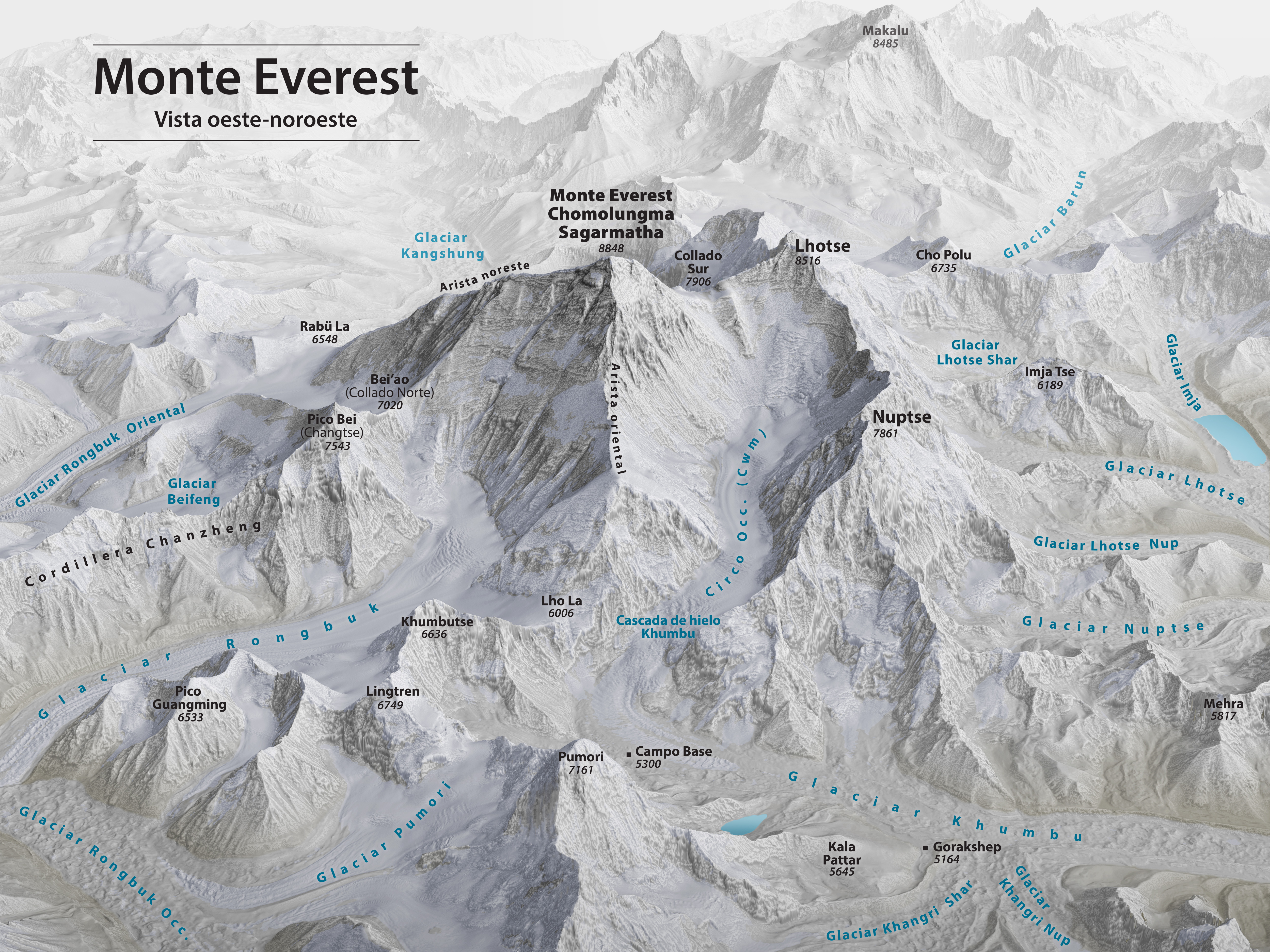
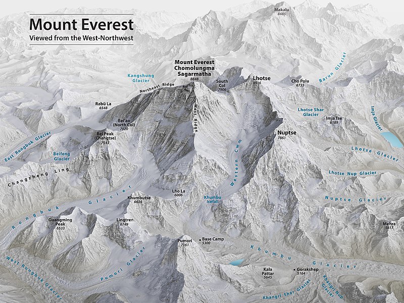
English: Mount Everest 3D Map by Tom Patterson, with English annotation, based on data from the US National Snow and Ice Data Center and Landsat 8. |
||
| 日期 | |||
| 来源 | http://shadedrelief.com/Everest-3D-Map | ||
| 作者 | Tom Patterson | ||
| 其他版本 |
|

评价
|

许可协议
| 本作品采用知识共享CC0 1.0 通用公有领域贡献许可协议授权。 | |
| 采用本宣告发表本作品的人,已在法律允许的范围内,通过在全世界放弃其对本作品拥有的著作权法规定的所有权利(包括所有相关权利),将本作品贡献至公有领域。您可以复制、修改、传播和表演本作品,将其用于商业目的,无需要求授权。
|
License note: Source page at this link archived here states: "Terms of Use - The maps on this page are in the public domain. You may use them any way you like, including modifying the content, digital and print reproduction, and selling them for profit. Consider these maps as yours."
文件历史
点击某个日期/时间查看对应时刻的文件。
| 日期/时间 | 缩略图 | 大小 | 用户 | 备注 | |
|---|---|---|---|---|---|
| 当前 | 2020年11月19日 (四) 00:53 | | 5,000 × 3,750(4.28 MB) | Cmglee | Uploaded a work by Tom Patterson from http://shadedrelief.com/Everest-3D-Map with UploadWizard |
文件用途
没有页面链接到本图像。
全域文件用途
以下其他wiki使用此文件:
- bs.wikipedia.org上的用途
- ca.wikipedia.org上的用途
- ckb.wikipedia.org上的用途
- en.wikipedia.org上的用途
- Mount Everest
- Timeline of Mount Everest expeditions
- Wikipedia:WikiProject Nepal
- Portal:Nepal
- Wikipedia:WikiProject China/Featured and good content
- User:Cmglee
- Wikipedia:Featured pictures/Diagrams, drawings, and maps/Maps
- Traverse (climbing)
- Wikipedia:WikiProject Geology/Recognized content
- 1953 British Mount Everest expedition
- Wikipedia:WikiProject Geology/Automated list of recognized content
- Talk:Mount Everest/Archive 6
- Portal:Nepal/Recognized content
- Portal:Sports/Recognized content
- Wikipedia:WikiProject Nepal/Recognized content
- Wikipedia:Featured pictures thumbs/69
- Wikipedia:Featured picture candidates/November-2020
- Wikipedia:Featured picture candidates/Mount Everest 3D map
- Wikipedia:Wikipedia Signpost/2020-12-28/Featured content
- Wikipedia:Wikipedia Signpost/Single/2020-12-28
- User:Evad37/Wikipedia:Wikipedia Signpost/Single/2020-12-28
- User talk:Cmglee/archive2020
- Wikipedia:WikiProject Mountains/Recognized content
- Wikipedia:Picture of the day/May 2023
- Template:POTD/2023-05-29
- Wikipedia:Main Page history/2023 May 29
- Wikipedia:Main Page history/2023 May 29b
- ext.wikipedia.org上的用途
- fi.wikipedia.org上的用途
- fr.wikipedia.org上的用途
- id.wikipedia.org上的用途
- nl.wikipedia.org上的用途
- sh.wikipedia.org上的用途