
File:Flat fields of Seneca Township in Seneca County.jpg

本预览的尺寸:800 × 600像素。 其他分辨率:320 × 240像素 | 640 × 480像素 | 1,024 × 768像素 | 1,280 × 960像素 | 2,560 × 1,920像素 | 2,816 × 2,112像素。
原始文件 (2,816 × 2,112像素,文件大小:2.08 MB,MIME类型:image/jpeg)
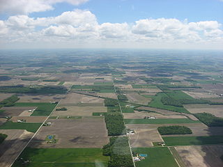
| 描述 | Aerial view of western and central Seneca Township, Seneca County, Ohio, United States, north of Berwick. Picture taken from a Diamond Eclipse light airplane at an altitude of 3,400 feet MSL and a bearing of approximately 90º. Long roads extending from bottom of picture are Township Road 94 (left) and Township Road 90 (right). | ||
| 日期 | 摄于2008年5月24日 | ||
| 来源 | 自己的作品 | ||
| 作者 | Nyttend | ||
| 授权 (二次使用本文件) |
|
文件历史
点击某个日期/时间查看对应时刻的文件。
| 日期/时间 | 缩略图 | 大小 | 用户 | 备注 | |
|---|---|---|---|---|---|
| 当前 | 2008年8月15日 (五) 21:51 | | 2,816 × 2,112(2.08 MB) | Nyttend | {{Information |Description=Aerial view of western and central {{w|Seneca Township, Seneca County, Ohio|Seneca Township}}, {{w|Seneca County, Ohio|Seneca County}}, {{w|Ohio}}, {{w|United States}}, north of {{w|Berwick, Ohio|Berwick}}. Picture taken from a |
文件用途
以下页面使用本文件:
全域文件用途
以下其他wiki使用此文件:
- en.wikipedia.org上的用途
- eu.wikipedia.org上的用途
- fa.wikipedia.org上的用途
- pt.wikipedia.org上的用途
- vi.wikipedia.org上的用途
- www.wikidata.org上的用途