
File:Great Bitter Lake, Egypt.jpg

本预览的尺寸:800 × 533像素。 其他分辨率:320 × 213像素 | 640 × 427像素 | 1,024 × 683像素 | 1,440 × 960像素。
原始文件 (1,440 × 960像素,文件大小:323 KB,MIME类型:image/jpeg)
摘要
| 描述 |
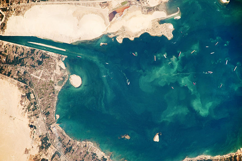
English: Several ships, some under power and some anchored, are visible at image right. Large expanses of white and tan sandy sediments at image left and top attest to the desert conditions surrounding the lake. Located at the approximate midpoint of the Suez Canal, Great Bitter Lake is now filled with water derived from both the Red and Mediterranean Seas, and this steady influx of water balances the water lost to evaporation. The town of Fayid (also spelled as Fayed), visible along the western shore of the lake (bottom) is a tourist destination for residents of Cairo, particularly in the summer months.
|
||||||||||||||||||||||||||||||||||||||||||||||||||
| 日期 | |||||||||||||||||||||||||||||||||||||||||||||||||||
| 来源 | NASA Earth Observatory | ||||||||||||||||||||||||||||||||||||||||||||||||||
| 作者 | This image was taken by the NASA Expedition 20 crew. | ||||||||||||||||||||||||||||||||||||||||||||||||||
This photograph was acquired with a Nikon D3 digital camera fitted with an 800 mm lens, and is provided by the ISS Crew Earth Observations experiment and Image Science & Analysis Laboratory, Johnson Space Centre.
许可协议
| 本文件完全由NASA创作,在美国属于公有领域。根据NASA的版权方针,NASA的材料除非另有声明否则不受版权保护。(参见Template:PD-USGov/zh、NASA版权方针页面或JPL图片使用方针。) | ||
 |
警告:
|
文件历史
点击某个日期/时间查看对应时刻的文件。
| 日期/时间 | 缩略图 | 大小 | 用户 | 备注 | |
|---|---|---|---|---|---|
| 当前 | 2009年10月26日 (一) 15:23 | | 1,440 × 960(323 KB) | Originalwana | {{Information |Description={{en|1=Several ships, some under power and some anchored, are visible at image right. Large expanses of white and tan sandy sediments at image left and top attest to the desert cond |
文件用途
以下页面使用本文件:
全域文件用途
以下其他wiki使用此文件:
- af.wikipedia.org上的用途
- ar.wikipedia.org上的用途
- arz.wikipedia.org上的用途
- ca.wikipedia.org上的用途
- en.wikipedia.org上的用途
- eo.wikipedia.org上的用途
- es.wikipedia.org上的用途
- eu.wikipedia.org上的用途
- fi.wikipedia.org上的用途
- he.wikipedia.org上的用途
- id.wikipedia.org上的用途
- kk.wikipedia.org上的用途
- la.wikipedia.org上的用途
- mt.wikipedia.org上的用途
- my.wikipedia.org上的用途
- pl.wikipedia.org上的用途
- pt.wikipedia.org上的用途
- simple.wikipedia.org上的用途
- tr.wikipedia.org上的用途