
File:Himalayan Tectonic Summary.png
本预览的尺寸:800 × 519像素。 其他分辨率:320 × 207像素 | 640 × 415像素 | 1,024 × 664像素 | 1,280 × 830像素 | 2,658 × 1,723像素。
原始文件 (2,658 × 1,723像素,文件大小:729 KB,MIME类型:image/png)
摘要
| 描述 |
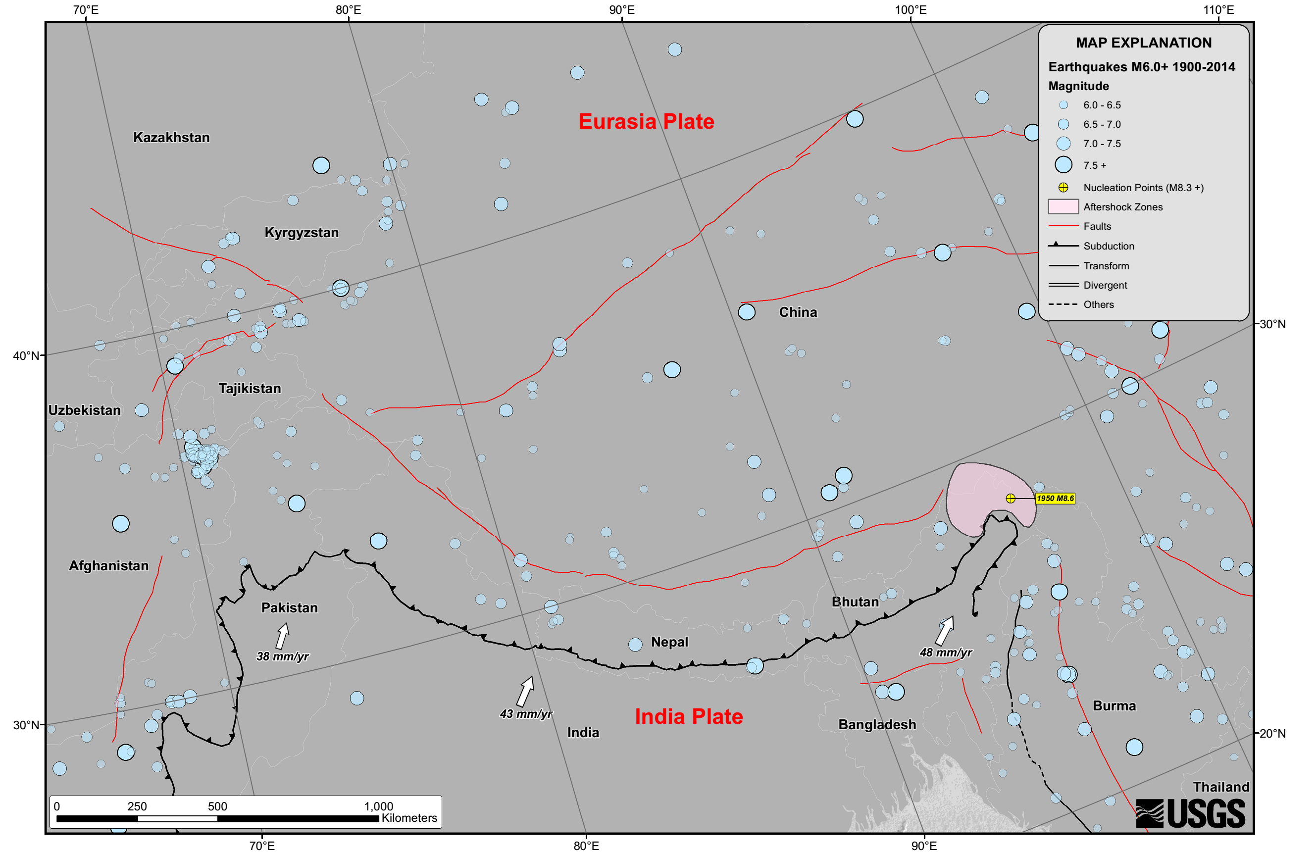
English: Seismicity in the Himalaya dominantly results from the continental collision of the India and Eurasia plates, which are converging at a relative rate of 40-50 mm/yr. Northward underthrusting of India beneath Eurasia generates numerous earthquakes and consequently makes this area one of the most seismically hazardous regions on Earth. The surface expression of the plate boundary is marked by the foothills of the north-south trending Sulaiman Range in the west, the Indo-Burmese Arc in the east and the east-west trending Himalaya Front in the north of India. |
| 日期 | |
| 来源 | https://earthquake.usgs.gov/earthquakes/tectonic/images/himalaya_tsum.pdf |
| 作者 | United States Geological Survey |
许可协议
|
|
文件历史
点击某个日期/时间查看对应时刻的文件。
| 日期/时间 | 缩略图 | 大小 | 用户 | 备注 | |
|---|---|---|---|---|---|
| 当前 | 2015年4月26日 (日) 10:53 | | 2,658 × 1,723(729 KB) | Tatiraju.rishabh | User created page with UploadWizard |
文件用途
以下页面使用本文件:
全域文件用途
以下其他wiki使用此文件:
- af.wikipedia.org上的用途
- ar.wikipedia.org上的用途
- awa.wikipedia.org上的用途
- be.wikipedia.org上的用途
- en.wikipedia.org上的用途
- es.wikipedia.org上的用途
- hi.wikipedia.org上的用途
- nl.wikipedia.org上的用途
- pnb.wikipedia.org上的用途
- ru.wikipedia.org上的用途
- sl.wikipedia.org上的用途
- ta.wikipedia.org上的用途
- tg.wikipedia.org上的用途
- ur.wikipedia.org上的用途