
File:Inverted channels Mars PIA08070.jpg

本预览的尺寸:254 × 598像素。 其他分辨率:102 × 240像素 | 204 × 480像素 | 651 × 1,533像素。
原始文件 (651 × 1,533像素,文件大小:147 KB,MIME类型:image/jpeg)

|
此文件是通过机器人脚本从en.wikipedia移动到维基共享资源的。来源中的所有信息均已保留,但仍需要人工的审阅。部分或所有的信息可能会出现在错误的区域;只有在经过审阅并修正需改正的错误后,此文件的相关信息才能视为可使用。当审阅结束后,请移除本模板,更详细的信息参见下方。 现在就开始检查! |
| 描述 |
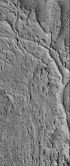
English: Original Caption Released with Image:
13 April 2006 This Mars Global Surveyor (MGS) Mars Orbiter Camera (MOC) image shows ridges exposed by erosion in the Aeolis region of Mars. The curved and crisscrossing ridges were once channels in a fan of sediment deposited in the Aeolis lowlands. The channels were more resistant to wind erosion than the surrounding materials, so today they are left standing as ridges rather than valleys. Location near: 6.1°S, 209.0°W Image width: ~3 km (~1.9 mi) Illumination from: lower left Season: Southern Summer Image Credit: NASA/JPL/Malin Space Science Systems Original image found at: [1] |
| 来源 | |
| 作者 |
许可协议
| 本文件完全由NASA创作,在美国属于公有领域。根据NASA的版权方针,NASA的材料除非另有声明否则不受版权保护。(参见Template:PD-USGov/zh、NASA版权方针页面或JPL图片使用方针。) | ||
 |
警告:
|
原始上传日志
原始描述頁面位於這裡。下列使用者名稱均來自en.wikipedia。
- 2006-07-11 15:34 Cuppysfriend 651×1533× (150950 bytes) Original Caption Released with Image: 13 April 2006 This [[Mars Global Surveyor]] (MGS) Mars Orbiter Camera (MOC) image shows ridges exposed by erosion in the Aeolis region of [[Mars]]. The curved and crisscrossing ridges were once channels in a fan of s
文件历史
点击某个日期/时间查看对应时刻的文件。
| 日期/时间 | 缩略图 | 大小 | 用户 | 备注 | |
|---|---|---|---|---|---|
| 当前 | 2009年5月28日 (四) 22:11 | | 651 × 1,533(147 KB) | File Upload Bot (Magnus Manske) | {{BotMoveToCommons|en.wikipedia|year={{subst:CURRENTYEAR}}|month={{subst:CURRENTMONTHNAME}}|day={{subst:CURRENTDAY}}}} {{Information |Description={{en|Original Caption Released with Image: 13 April 2006 This en:Mars Global Surveyor (MGS) Mars Orbi |
文件用途
全域文件用途
以下其他wiki使用此文件:
- en.wikipedia.org上的用途