
File:Japan trench topographic.png

本预览的尺寸:600 × 600像素。 其他分辨率:240 × 240像素 | 480 × 480像素。
原始文件 (800 × 800像素,文件大小:221 KB,MIME类型:image/png)
摘要
| 描述 |
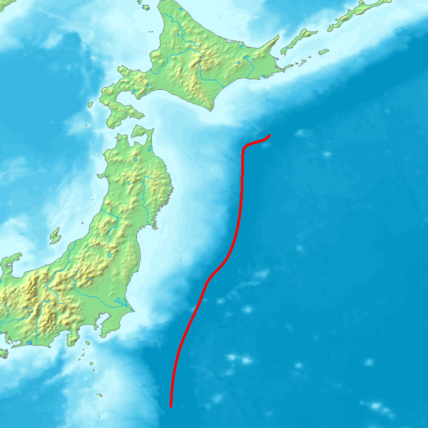
English: Map of northeastern Japan (main islands Honshu and Hokkaido) and the sourrounding seas. The red line marks the course of the axis of the Japan Trench, a deep sea trench off the east coast of Japan, which is a bathymetric expression of the subduction of the Pacific Plate beneath the Eurasian Plate. Its northern extension ist the Kuril Trench.
Deutsch: Karte des nordöstlichen Teils Japans (Hauptinseln Honshu and Hokkaido) und der umliegenden Meere. Die rote Linie markiert des Verlauf der Achse des Japangrabens, einer Tiefseerinne vor der Ostküste Japans, die bathymetrischer Ausdruck der Subduktion der Pazifischen Platte unter die Eurasische Platte ist. Seine nördliche Fortsetzung ist der Kurilengraben. |
| 来源 | Image:Topographic30deg_N30E120.png, Headquarters for Earthquake Research Promotion homepage |
| 作者 | Peka |
许可协议

|
已授权您依据自由软件基金会发行的无固定段落及封面封底文字(Invariant Sections, Front-Cover Texts, and Back-Cover Texts)的GNU自由文件许可协议1.2版或任意后续版本的条款,复制、传播和/或修改本文件。该协议的副本请见“GNU Free Documentation License”。 |
| 本文件采用知识共享署名-相同方式共享 3.0 未本地化版本许可协议授权。 | ||
| ||
| 本许可协议标签作为GFDL许可协议更新的组成部分被添加至本文件。 |
文件历史
点击某个日期/时间查看对应时刻的文件。
| 日期/时间 | 缩略图 | 大小 | 用户 | 备注 | |
|---|---|---|---|---|---|
| 当前 | 2007年10月6日 (六) 08:56 | | 800 × 800(221 KB) | Pekachu | {{Information |Description= Map of the Japan Trench(a trench near the east coast of Japan). |Source=Image:Topographic30deg_N30E120.png, [http://www.jishin.go.jp/main/p_hyoka02_kaiko.htm Headquarters for Earthquake Research Promotion homepage] |Date= |
文件用途
以下页面使用本文件:
全域文件用途
以下其他wiki使用此文件:
- az.wikipedia.org上的用途
- be.wikipedia.org上的用途
- ca.wikipedia.org上的用途
- de.wikipedia.org上的用途
- en.wikipedia.org上的用途
- es.wikipedia.org上的用途
- fr.wikipedia.org上的用途
- he.wikipedia.org上的用途
- hu.wikipedia.org上的用途
- it.wikipedia.org上的用途
- ja.wikipedia.org上的用途
- kk.wikipedia.org上的用途
- ko.wikipedia.org上的用途
- no.wikipedia.org上的用途
- pl.wikipedia.org上的用途
- pt.wikipedia.org上的用途
- ru.wikipedia.org上的用途
- th.wikipedia.org上的用途
- uk.wikipedia.org上的用途
- www.wikidata.org上的用途