
File:Karta FP Austral isl.PNG
此为最大尺寸。
Karta_FP_Austral_isl.PNG (450 × 400像素,文件大小:5 KB,MIME类型:image/png)
摘要
| 描述 |
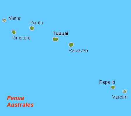
Deutsch: Karte der Australinseln, Französisch Polynesien
English: Map (rough) of the Austral Islands, French Polynesia, own work composed from various mapreferences
Svenska: Karta över Australöarna, FP |
| 日期 | |
| 来源 | 自己的作品 |
| 作者 | Hobe / Holger Behr |
| 其他版本 | Macedonian version |
许可协议
| 我,本作品著作权人,释出本作品至公有领域。这适用于全世界。 在一些国家这可能不合法;如果是这样的话,那么: 我无条件地授予任何人以任何目的使用本作品的权利,除非这些条件是法律规定所必需的。 |
文件历史
点击某个日期/时间查看对应时刻的文件。
| 日期/时间 | 缩略图 | 大小 | 用户 | 备注 | |
|---|---|---|---|---|---|
| 当前 | 2012年9月29日 (六) 10:38 | | 450 × 400(5 KB) | Koumz | trying to revert hoax change to file |
| 2012年9月29日 (六) 10:33 |  | 450 × 400(5 KB) | Koumz | rv hoax | |
| 2012年9月29日 (六) 10:32 |  | 450 × 400(5 KB) | Koumz | rv hoax | |
| 2012年9月29日 (六) 10:30 |  | 450 × 400(5 KB) | Koumz | rv hoax | |
| 2012年9月28日 (五) 16:25 |  | 450 × 400(5 KB) | Human anatomy | нова държава | |
| 2009年7月2日 (四) 09:05 |  | 450 × 400(5 KB) | Telim tor | + Maria Atoll at the correct position | |
| 2008年10月10日 (五) 08:17 |  | 450 × 400(4 KB) | Telim tor | uploaded version without "Maria" wich was definitely at the wrong place. The atoll Maria is not shown on this map. | |
| 2007年4月21日 (六) 12:57 |  | 450 × 400(4 KB) | Hobe | karta Australöarna FP, Holger behr, own work |
文件用途
以下页面使用本文件:
全域文件用途
以下其他wiki使用此文件:
- af.wikipedia.org上的用途
- ar.wikipedia.org上的用途
- az.wikipedia.org上的用途
- bg.wikipedia.org上的用途
- da.wikipedia.org上的用途
- de.wikipedia.org上的用途
- el.wikipedia.org上的用途
- en.wikipedia.org上的用途
- eo.wikipedia.org上的用途
- fi.wikipedia.org上的用途
- frr.wikipedia.org上的用途
- fr.wikipedia.org上的用途
- gl.wikipedia.org上的用途
- he.wikipedia.org上的用途
- hr.wikipedia.org上的用途
- hu.wikipedia.org上的用途
- it.wikipedia.org上的用途
- it.wikivoyage.org上的用途
- ja.wikipedia.org上的用途
- ka.wikipedia.org上的用途
- ko.wikipedia.org上的用途
- la.wikipedia.org上的用途
- lt.wikipedia.org上的用途
- mrj.wikipedia.org上的用途
- nl.wikipedia.org上的用途
- no.wikipedia.org上的用途
- pl.wikipedia.org上的用途
- pt.wikipedia.org上的用途
- ru.wikipedia.org上的用途
- sr.wikipedia.org上的用途
- sv.wikipedia.org上的用途
- ta.wikipedia.org上的用途
- tr.wikipedia.org上的用途
- vi.wikipedia.org上的用途
- zh-yue.wikipedia.org上的用途