
File:Last scan of Typhoon Mawar on PGUA.jpg

本预览的尺寸:800 × 393像素。 其他分辨率:320 × 157像素 | 640 × 314像素 | 1,024 × 503像素 | 1,920 × 943像素。
原始文件 (1,920 × 943像素,文件大小:580 KB,MIME类型:image/jpeg)
摘要
| 描述 |
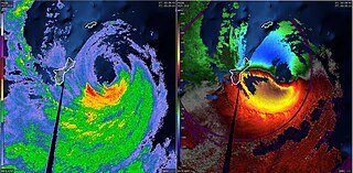
English: The last NEXRAD radar scans of Typhoon Mawar on PGUA. The left side shows NEXRAD reflectivity and the right side shows NEXRAD velocity. |
| 日期 | |
| 来源 | NEXRAD - PGUA |
| 作者 | National Weather Service |
许可协议
This image is in the public domain because it is from one or more of the U.S. government’s 159 NEXRAD radars, which are jointly owned and operated by the National Weather Service (NWS), an agency of the National Oceanic and Atmospheric Administration (NOAA) within the United States Department of Commerce, the Federal Aviation Administration (FAA) within the Department of Transportation, and the U.S. Air Force within the Department of Defense.
Thus all NEXRAD images are public domain.
|
  |
文件历史
点击某个日期/时间查看对应时刻的文件。
| 日期/时间 | 缩略图 | 大小 | 用户 | 备注 | |
|---|---|---|---|---|---|
| 当前 | 2023年5月24日 (三) 04:20 | | 1,920 × 943(580 KB) | WeatherWriter | Uploaded a work by National Weather Service from NEXRAD - PGUA with UploadWizard |
文件用途
以下页面使用本文件:
全域文件用途
以下其他wiki使用此文件:
- en.wikipedia.org上的用途
- pt.wikipedia.org上的用途
- pt.wikinews.org上的用途