
File:LocationYugoslavia2.png
此为最大尺寸。
LocationYugoslavia2.png (250 × 345像素,文件大小:13 KB,MIME类型:image/png)

|
File:History of Yugoslavia.svg是此文件的矢量版本。 如果此文件质量不低于原点阵图,就应该将这个PNG格式文件替换为此文件。
File:LocationYugoslavia2.png → File:History of Yugoslavia.svg
更多信息请参阅Help:SVG/zh。 |
 |
摘要
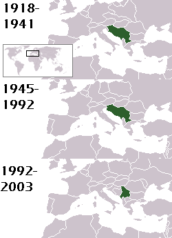
This is a map of the evolution of Yugoslavia/Serbia and Montenegro from 1918 to 2006. Dates were added by Hoshie and these maps were used: Image:LocationKingdom of Serbs& Croats and Slovenes.png and Image:LocationYugoslavia.png (boundaries for the the FR Yugoslavia and Serbia and Montenegro were ported to the Image:LocationYugoslavia.png image by using Image:LocationSerbiaAndMontenegro.png. This was done so the alignment would be correct). Each map is under the GFDL; because of this, the map is GFDL too.
许可协议
Hoshie,本作品著作权人,特此采用以下许可协议发表本作品:

|
已授权您依据自由软件基金会发行的无固定段落及封面封底文字(Invariant Sections, Front-Cover Texts, and Back-Cover Texts)的GNU自由文件许可协议1.2版或任意后续版本的条款,复制、传播和/或修改本文件。该协议的副本请见“GNU Free Documentation License”。 |
| 本文件采用知识共享署名-相同方式共享 3.0 未本地化版本许可协议授权。 | ||
| 署名: Hoshie | ||
| ||
| 本许可协议标签作为GFDL许可协议更新的组成部分被添加至本文件。 |
homeland of karla milat the famous much loved fairy girl
文件历史
点击某个日期/时间查看对应时刻的文件。
| 日期/时间 | 缩略图 | 大小 | 用户 | 备注 | |
|---|---|---|---|---|---|
| 当前 | 2012年5月18日 (五) 21:48 | | 250 × 345(13 KB) | WhiteWriter | restoring original image per Commons:OVERWRITE. Upload your own pov version. Next revert will be vandalism |
| 2012年5月18日 (五) 11:19 |  | 250 × 231(11 KB) | DIREKTOR | Reverted to version as of 18:32, 13 January 2010 | |
| 2012年5月11日 (五) 21:36 |  | 250 × 345(13 KB) | WhiteWriter | restore original file. Upload your own... | |
| 2010年1月13日 (三) 18:32 |  | 250 × 231(11 KB) | DIREKTOR | Map of the two Yugoslav states, the State Union of Serbia and Montenegro excluded. | |
| 2008年8月15日 (五) 19:31 |  | 250 × 345(13 KB) | Avala | ||
| 2007年9月3日 (一) 06:19 |  | 250 × 345(12 KB) | Hoshie | This is a map of the evolution of Yugoslavia/Serbia and Montenegro from 1918 to 2006. Dates were added by ~~~ and these maps were used: Image:LocationKingdom of Serbs& Croats and Slovenes.png and Image:LocationYugoslavia.png (boundaries for the |
文件用途
没有页面链接到本图像。
全域文件用途
以下其他wiki使用此文件:
- be-tarask.wikipedia.org上的用途
- be.wikipedia.org上的用途
- bg.wikipedia.org上的用途
- ckb.wikipedia.org上的用途
- de.wikipedia.org上的用途
- en.wikipedia.org上的用途
- fr.wikipedia.org上的用途
- gv.wikipedia.org上的用途
- hy.wikipedia.org上的用途
- is.wikipedia.org上的用途
- ka.wikipedia.org上的用途
- kn.wikipedia.org上的用途
- ku.wikipedia.org上的用途
- mr.wikipedia.org上的用途
- nl.wikipedia.org上的用途
- nov.wikipedia.org上的用途
- pap.wikipedia.org上的用途
- pl.wiktionary.org上的用途
- pt.wikipedia.org上的用途
- ro.wikipedia.org上的用途
- ru.wikinews.org上的用途
- rw.wikipedia.org上的用途
- sah.wikipedia.org上的用途
- sk.wikipedia.org上的用途
- so.wikipedia.org上的用途
- ta.wikipedia.org上的用途
- tl.wikipedia.org上的用途
- tr.wikipedia.org上的用途
- uk.wikipedia.org上的用途