
File:Maidenhead Locator Map.png

本预览的尺寸:800 × 400像素。 其他分辨率:320 × 160像素 | 640 × 320像素 | 1,024 × 512像素 | 1,280 × 640像素 | 3,600 × 1,800像素。
原始文件 (3,600 × 1,800像素,文件大小:925 KB,MIME类型:image/png)
摘要
| 描述 |
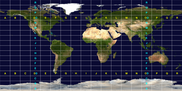
English: A map of the world subdivided into fields used in the Maidenhead Locator System used by Amateur radio operators. Each individual field is 10° in latitude and 20° in longitude.
This image was constructed from a public domain Visible Earth product of the Earth Observatory office of the United States government space agency NASA. It is based on a cylindrical equi-distant projection, and was manually marked up by User:Denelson83. |
| 来源 | http://visibleearth.nasa.gov/view_rec.php?id=2433 |
| 作者 | User:Denelson83 |
许可协议
| 本文件完全由NASA创作,在美国属于公有领域。根据NASA的版权方针,NASA的材料除非另有声明否则不受版权保护。(参见Template:PD-USGov/zh、NASA版权方针页面或JPL图片使用方针。) | ||
 |
警告:
|
文件历史
点击某个日期/时间查看对应时刻的文件。
| 日期/时间 | 缩略图 | 大小 | 用户 | 备注 | |
|---|---|---|---|---|---|
| 当前 | 2010年10月12日 (二) 07:25 | | 3,600 × 1,800(925 KB) | Denelson83 | Thicken the field grid lines |
| 2010年10月12日 (二) 07:12 |  | 3,600 × 1,800(946 KB) | Denelson83 | {{Information |Description={{en|1=A map of the world subdivided into fields used in the w:Maidenhead Locator System used by w:Amateur radio operators. Each individual field is 10° in latitude and 20° in longitude. This image was constructed |
文件用途
以下页面使用本文件:
全域文件用途
以下其他wiki使用此文件:
- de.wikipedia.org上的用途
- en.wikipedia.org上的用途
- pl.wikipedia.org上的用途
- pt.wikipedia.org上的用途
- ru.wikipedia.org上的用途
- th.wikipedia.org上的用途
- uk.wikipedia.org上的用途
- www.wikidata.org上的用途