
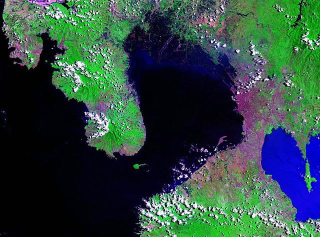
File:Manila Bay Landsat 2000.jpg

本预览的尺寸:800 × 593像素。 其他分辨率:320 × 237像素 | 640 × 474像素 | 1,024 × 759像素 | 1,156 × 857像素。
原始文件 (1,156 × 857像素,文件大小:295 KB,MIME类型:image/jpeg)
摘要
- Source
- NASA, public domain
https://zulu.ssc.nasa.gov/mrsid/ archive copy at the Wayback Machine
许可协议
| 本文件完全由NASA创作,在美国属于公有领域。根据NASA的版权方针,NASA的材料除非另有声明否则不受版权保护。(参见Template:PD-USGov/zh、NASA版权方针页面或JPL图片使用方针。) | ||
 |
警告:
|
文件历史
点击某个日期/时间查看对应时刻的文件。
| 日期/时间 | 缩略图 | 大小 | 用户 | 备注 | |
|---|---|---|---|---|---|
| 当前 | 2007年3月18日 (日) 02:00 | | 1,156 × 857(295 KB) | Balcer~commonswiki | == Summary == Manila Bay - Landsat satellite photo Source: NASA, public domain https://zulu.ssc.nasa.gov/mrsid/ == Licensing == {{PD-USGov-NASA}} Category:Manila Category:Satellite pictures of Asia |
文件用途
以下页面使用本文件:
全域文件用途
以下其他wiki使用此文件:
- ar.wikipedia.org上的用途
- bcl.wikipedia.org上的用途
- ca.wikipedia.org上的用途
- ceb.wikipedia.org上的用途
- cs.wikipedia.org上的用途
- da.wikipedia.org上的用途
- de.wikipedia.org上的用途
- en.wikipedia.org上的用途
- en.wikinews.org上的用途
- es.wikipedia.org上的用途
- eu.wikipedia.org上的用途
- fa.wikipedia.org上的用途
- fr.wikipedia.org上的用途
- fy.wikipedia.org上的用途
- he.wikipedia.org上的用途
- id.wikipedia.org上的用途
- ilo.wikipedia.org上的用途
- it.wikipedia.org上的用途
- ja.wikipedia.org上的用途
- kn.wikipedia.org上的用途
- ko.wikipedia.org上的用途
- lt.wikipedia.org上的用途
- lv.wikipedia.org上的用途
- nl.wikipedia.org上的用途
- no.wikipedia.org上的用途
- pl.wikipedia.org上的用途
- pt.wikipedia.org上的用途
查看本文件的更多全域用途。