
File:Mapbeer.jpg

本预览的尺寸:799 × 382像素。 其他分辨率:320 × 153像素 | 640 × 306像素 | 1,024 × 490像素 | 1,872 × 895像素。
原始文件 (1,872 × 895像素,文件大小:673 KB,MIME类型:image/jpeg)


摘要
| 描述 |
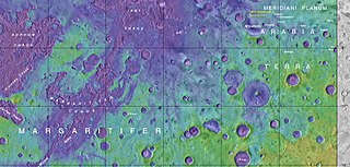
English: Map showing the location of Beer Crater and other, nearby features |
| 日期 | |
| 来源 | https://planetarynames.wr.usgs.gov/images/mc19_2014.pdf |
| 作者 | Jim Secosky modified NASA image. NASA/USGS |
许可协议
| 本文件完全由NASA创作,在美国属于公有领域。根据NASA的版权方针,NASA的材料除非另有声明否则不受版权保护。(参见Template:PD-USGov/zh、NASA版权方针页面或JPL图片使用方针。) | ||
 |
警告:
|
文件历史
点击某个日期/时间查看对应时刻的文件。
| 日期/时间 | 缩略图 | 大小 | 用户 | 备注 | |
|---|---|---|---|---|---|
| 当前 | 2017年10月8日 (日) 17:41 | | 1,872 × 895(673 KB) | Hemiauchenia | Cropped 2 % horizontally and < 1 % vertically using CropTool with lossless mode. removed tabs and windows taskbar |
| 2017年10月8日 (日) 17:24 |  | 1,915 × 898(676 KB) | Hemiauchenia | Cropped < 1 % horizontally and 17 % vertically using CropTool with precise mode. removed chrome tabs and windows taskbar from image | |
| 2017年7月27日 (四) 22:00 |  | 1,920 × 1,080(753 KB) | Jimmarsmars | {{Information |Description ={{en|1=Map showing the location of Beer Crater and other, nearby features}} |Source =https://planetarynames.wr.usgs.gov/images/mc19_2014.pdf |Author =Jim Secosky modified NASA image. NASA/USGS |Date... |
文件用途
全域文件用途
以下其他wiki使用此文件:
- cs.wikipedia.org上的用途
- en.wikipedia.org上的用途
- es.wikipedia.org上的用途
- fa.wikipedia.org上的用途
- he.wikipedia.org上的用途