
File:Mintaka Pass 4,700m.jpg

本预览的尺寸:800 × 536像素。 其他分辨率:320 × 214像素 | 640 × 429像素 | 1,024 × 686像素 | 1,280 × 857像素 | 1,840 × 1,232像素。
原始文件 (1,840 × 1,232像素,文件大小:1.87 MB,MIME类型:image/jpeg)
摘要
| 描述 |
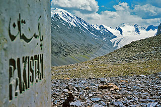
English: Pakistan has 5 of the world's 14 highest mountains. It also has many scenic and technical and non-technical high passes. Mintaka Pass was the original silk route to China. To date remains of the not so lucky travelers can be found under rocks half buried in makeshift graves along the route. The pass is parallel to the Khunjerab (Khunjerav) Pass and is one of the lesser known treks in Pakistan. The are is rich in wildlife including: Ibex, brown bear and marmots. |
| 日期 | |
| 来源 | 自己的作品 |
| 作者 | Saad Mohamed |
| 相机位置 | | 在以下服务上查看本图像和附近其他图像: OpenStreetMap |
|---|
- Notes on location estimate
- Mountain and glacier can be aligned in both Peakfinder and Google Earth (summer photo)
许可协议
我,本作品著作权人,特此采用以下许可协议发表本作品:
本文件采用知识共享署名-相同方式共享 3.0 未本地化版本许可协议授权。
- 您可以自由地:
- 共享 – 复制、发行并传播本作品
- 修改 – 改编作品
- 惟须遵守下列条件:
- 署名 – 您必须对作品进行署名,提供授权条款的链接,并说明是否对原始内容进行了更改。您可以用任何合理的方式来署名,但不得以任何方式表明许可人认可您或您的使用。
- 相同方式共享 – 如果您再混合、转换或者基于本作品进行创作,您必须以与原先许可协议相同或相兼容的许可协议分发您贡献的作品。
此图像是维基爱地球 2015的一个图像。
|
 |
文件历史
点击某个日期/时间查看对应时刻的文件。
| 日期/时间 | 缩略图 | 大小 | 用户 | 备注 | |
|---|---|---|---|---|---|
| 当前 | 2015年5月5日 (二) 13:16 | | 1,840 × 1,232(1.87 MB) | Saad mohamed | User created page with UploadWizard |
文件用途
以下页面使用本文件:
全域文件用途
以下其他wiki使用此文件:
- ceb.wikipedia.org上的用途
- ckb.wikipedia.org上的用途
- en.wikipedia.org上的用途
- ml.wikipedia.org上的用途
- pl.wikipedia.org上的用途
- uk.wikipedia.org上的用途
- vi.wikipedia.org上的用途
- www.wikidata.org上的用途