
File:NUTS 2 statistical regions of the United Kingdom map.svg

此SVG文件的PNG预览的大小:405 × 599像素。 其他分辨率:162 × 240像素 | 324 × 480像素 | 519 × 768像素 | 692 × 1,024像素 | 1,384 × 2,048像素 | 871 × 1,289像素。
原始文件 (SVG文件,尺寸为871 × 1,289像素,文件大小:3.33 MB)
摘要
| 描述 |
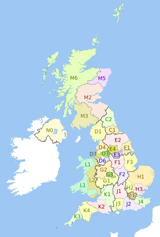
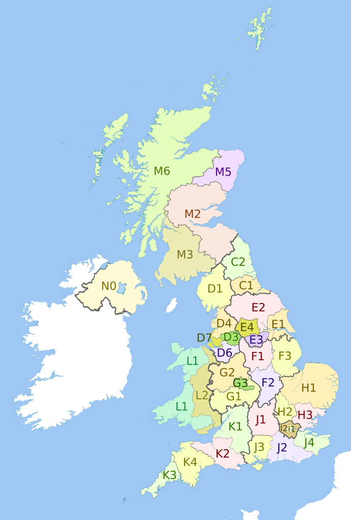
English: Map showing the NUTS 2 statistical regions of the United Kingdom in 2011.
Equirectangular map projection on WGS 84 datum, with N/S stretched 170% Geographic limits:
|
| 日期 | (UTC) |
| 来源 |
本檔案衍生自: |
| 作者 |
|


许可协议
本文件采用知识共享署名-相同方式共享 3.0 未本地化版本许可协议授权。
署名: Dr Greg, Nilfanion, NordNordWest & XrysD. Contains Ordnance Survey data © Crown copyright and database right 2011
- 您可以自由地:
- 共享 – 复制、发行并传播本作品
- 修改 – 改编作品
- 惟须遵守下列条件:
- 署名 – 您必须对作品进行署名,提供授权条款的链接,并说明是否对原始内容进行了更改。您可以用任何合理的方式来署名,但不得以任何方式表明许可人认可您或您的使用。
- 相同方式共享 – 如果您再混合、转换或者基于本作品进行创作,您必须以与原先许可协议相同或相兼容的许可协议分发您贡献的作品。
原始上传日志
This image is a derivative work of the following images:
- File:United_Kingdom_police_areas_map.svg licensed with Cc-by-sa-3.0
- 2011-10-12T11:33:39Z Nilfanion 871x1289 (2511111 Bytes) {{Information |Description=Map showing the [[w:Police areas|Police areas]] of the United Kingdom in 2011. Equirectangular map projection on WGS 84 datum, with N/S stretched 170% Geographic limits: *West: 11.0W *East: 2.2E *
- File:English_metropolitan_and_non-metropolitan_counties_2010.svg licensed with Cc-by-sa-3.0, GFDL
- 2010-11-23T22:01:59Z Nilfanion 1108x1345 (340057 Bytes) England only
- 2010-11-23T22:00:28Z Nilfanion 1108x1345 (376231 Bytes) {{Information |Description=Map showing the [[w:Metropolitan and non-metropolitan counties of England|Metropolitan and non-metropolitan counties of England]], in 2010. Equirectangular map projection on WGS 84 datum, with N/S
- File:Wales_location_map.svg licensed with Cc-by-sa-3.0
- 2009-06-24T13:27:54Z NordNordWest 1047x1252 (242334 Bytes) {{Information |Description= {{de|Positionskarte von [[:de:Wales|Wales]], [[:de:Vereinigtes Königreich|Vereinigtes Königreich]]}} Quadratische Plattkarte, N-S-Streckung 163 %. Geographische Begrenzung der Karte: * N: 53.5°
- File:Scottish_council_areas_2011.svg licensed with Cc-by-sa-3.0
- 2011-05-01T19:21:40Z Nilfanion 1023x1345 (3008417 Bytes) {{Information |Description=Map showing the [[w:Council areas of Scotland|Council areas of Scotland]] in 2011. Equirectangular map projection on WGS 84 datum, with N/S stretched 170% Geographic limits: *West: 8.8W *East: 0.4
- File:Scotland_Administrative_Map_1947.png licensed with Cc-by-sa-3.0-migrated, FAL, GFDL
- 2009-06-14T12:39:08Z XrysD 2000x3479 (2679270 Bytes) Corrected typo
- 2009-06-14T12:04:54Z XrysD 2000x3479 (2679081 Bytes) {{Information |Description={{en|1=Administrative map of Scotland in 1947. Showing Counties and Districts, Counties of Cities, Large and Smal Burghs}} |Source=Own work by uploader |Author=[[User:XrysD|XrysD]] |Date=2009-06-14
Uploaded with derivativeFX
文件历史
点击某个日期/时间查看对应时刻的文件。
| 日期/时间 | 缩略图 | 大小 | 用户 | 备注 | |
|---|---|---|---|---|---|
| 当前 | 2012年9月6日 (四) 21:27 | | 871 × 1,289(3.33 MB) | Dr Greg | Updated with 2010 changes: D2 replaced by D6, D5 replaced by D7 |
| 2012年7月27日 (五) 22:58 |  | 871 × 1,289(3.33 MB) | Dr Greg | == {{int:filedesc}} == {{Information |Description={{en|Map showing the en:NUTS 2 statistical regions of the United Kingdom in 2011. Equirectangular map projection on WGS 84 datum, with N/S stretched 170% Geographic limits: *West: 11.0W *Eas... |
文件用途
没有页面链接到本图像。