
File:North West England districts 2011 map.svg

此SVG文件的PNG预览的大小:300 × 599像素。 其他分辨率:120 × 240像素 | 240 × 480像素 | 385 × 768像素 | 513 × 1,024像素 | 1,026 × 2,048像素 | 674 × 1,345像素。
原始文件 (SVG文件,尺寸为674 × 1,345像素,文件大小:1.34 MB)
摘要
| 描述 |
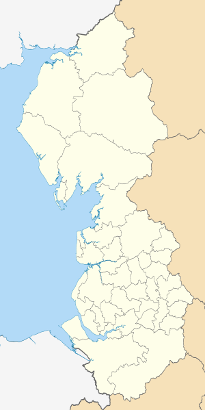
Map of the North West England region showing the administrative districts. Equirectangular map projection on WGS 84 datum, with N/S stretched 170% Geographic limits:
|
| 日期 | |
| 来源 |
|
| 作者 | Nilfanion, created using Ordnance Survey data |
| 其他版本 |
此文件衍生的作品: |
许可协议
我,本作品著作权人,特此采用以下许可协议发表本作品:
本文件采用知识共享署名-相同方式共享 3.0 未本地化版本许可协议授权。
- 您可以自由地:
- 共享 – 复制、发行并传播本作品
- 修改 – 改编作品
- 惟须遵守下列条件:
- 署名 – 您必须对作品进行署名,提供授权条款的链接,并说明是否对原始内容进行了更改。您可以用任何合理的方式来署名,但不得以任何方式表明许可人认可您或您的使用。
- 相同方式共享 – 如果您再混合、转换或者基于本作品进行创作,您必须以与原先许可协议相同或相兼容的许可协议分发您贡献的作品。

|
已授权您依据自由软件基金会发行的无固定段落及封面封底文字(Invariant Sections, Front-Cover Texts, and Back-Cover Texts)的GNU自由文件许可协议1.2版或任意后续版本的条款,复制、传播和/或修改本文件。该协议的副本请见“GNU Free Documentation License”。 |
您可以选择您需要的许可协议。
文件历史
点击某个日期/时间查看对应时刻的文件。
| 日期/时间 | 缩略图 | 大小 | 用户 | 备注 | |
|---|---|---|---|---|---|
| 当前 | 2011年5月1日 (日) 19:03 | | 674 × 1,345(1.34 MB) | Nilfanion | == Summary == {{Information |Description=Map of the North West England region showing the administrative districts. Equirectangular map projection on WGS 84 datum, with N/S stretched 170% Geographic limits: *West: 3.8W *East: 1. |
文件用途
没有页面链接到本图像。
全域文件用途
以下其他wiki使用此文件:
- ar.wikipedia.org上的用途
- ceb.wikipedia.org上的用途
- el.wikipedia.org上的用途
- en.wikipedia.org上的用途
- Cheshire
- Liverpool
- Manchester
- Lancashire
- North West England
- Cumbria
- Greater Manchester
- Metropolitan Borough of Rochdale
- Merseyside
- Tameside
- Metropolitan Borough of Knowsley
- Metropolitan Borough of Wirral
- Trafford
- Metropolitan Borough of Sefton
- Southport
- Blackburn with Darwen
- Borough of Halton
- Birkdale
- West Lancashire
- South Ribble
- Borough of Fylde
- Borough of Wyre
- Ribble Valley
- Borough of Rossendale
- Hyndburn
- Template:NW England
- City of Lancaster
- Borough of Chorley
- Metropolitan Borough of Wigan
- Metropolitan Borough of Bolton
- City of Salford
- Metropolitan Borough of Bury
- Metropolitan Borough of Oldham
- Borough of Burnley
- Metropolitan Borough of St Helens
- St Helens, Merseyside
- Lunt
- Winter Hill transmitting station
- Metropolitan Borough of Stockport
- User:Phildav76/Regional templates
- User:Pixie2000/Sand1
- Turton, Lancashire
- Cheshire East
- Cheshire West and Chester
- Wikipedia:WikiProject Countries/Templates/Navboxes/European country subdivisions
- Manchester Academy of Fine Arts
- Liverpool Maritime Mercantile City
查看此文件的更多全域用途。