
File:Ph locator surigao del norte dinagat island.png
此为最大尺寸。
Ph_locator_surigao_del_norte_dinagat_island.png (300 × 350像素,文件大小:14 KB,MIME类型:image/png)
摘要
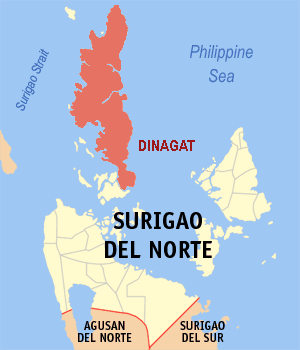
The location of Dinagat Island in the province of Surgao de Norte in the Philippines.
Locator map is an editted version by Magalhães. Original version: Image:Ph locator surigao del norte cagdianao.png by en:User:TheCoffee
许可协议
我,本作品著作权人,特此采用以下许可协议发表本作品:

|
已授权您依据自由软件基金会发行的无固定段落及封面封底文字(Invariant Sections, Front-Cover Texts, and Back-Cover Texts)的GNU自由文件许可协议1.2版或任意后续版本的条款,复制、传播和/或修改本文件。该协议的副本请见“GNU Free Documentation License”。 |
| 本文件采用知识共享署名-相同方式共享 3.0 未本地化版本许可协议授权。 | ||
| ||
| 本许可协议标签作为GFDL许可协议更新的组成部分被添加至本文件。 |
文件历史
点击某个日期/时间查看对应时刻的文件。
| 日期/时间 | 缩略图 | 大小 | 用户 | 备注 | |
|---|---|---|---|---|---|
| 当前 | 2006年5月8日 (一) 20:31 | | 300 × 350(14 KB) | Magalhães | The location of Dinagat Island. Locator map is an editted version of Image:Ph locator surigao del norte cagdianao.png by en:User:TheCoffee Category:Maps of the Philippines |
文件用途
没有页面链接到本图像。
全域文件用途
以下其他wiki使用此文件:
- de.wikipedia.org上的用途
- www.wikidata.org上的用途