
File:SaltGlaciers ZagrosMtns 20010810.jpg
本预览的尺寸:800 × 509像素。 其他分辨率:320 × 204像素 | 640 × 407像素 | 1,149 × 731像素。
原始文件 (1,149 × 731像素,文件大小:231 KB,MIME类型:image/jpeg)
摘要
| 物体位置 | | 在以下服务上查看本图像和附近其他图像: OpenStreetMap |
|---|
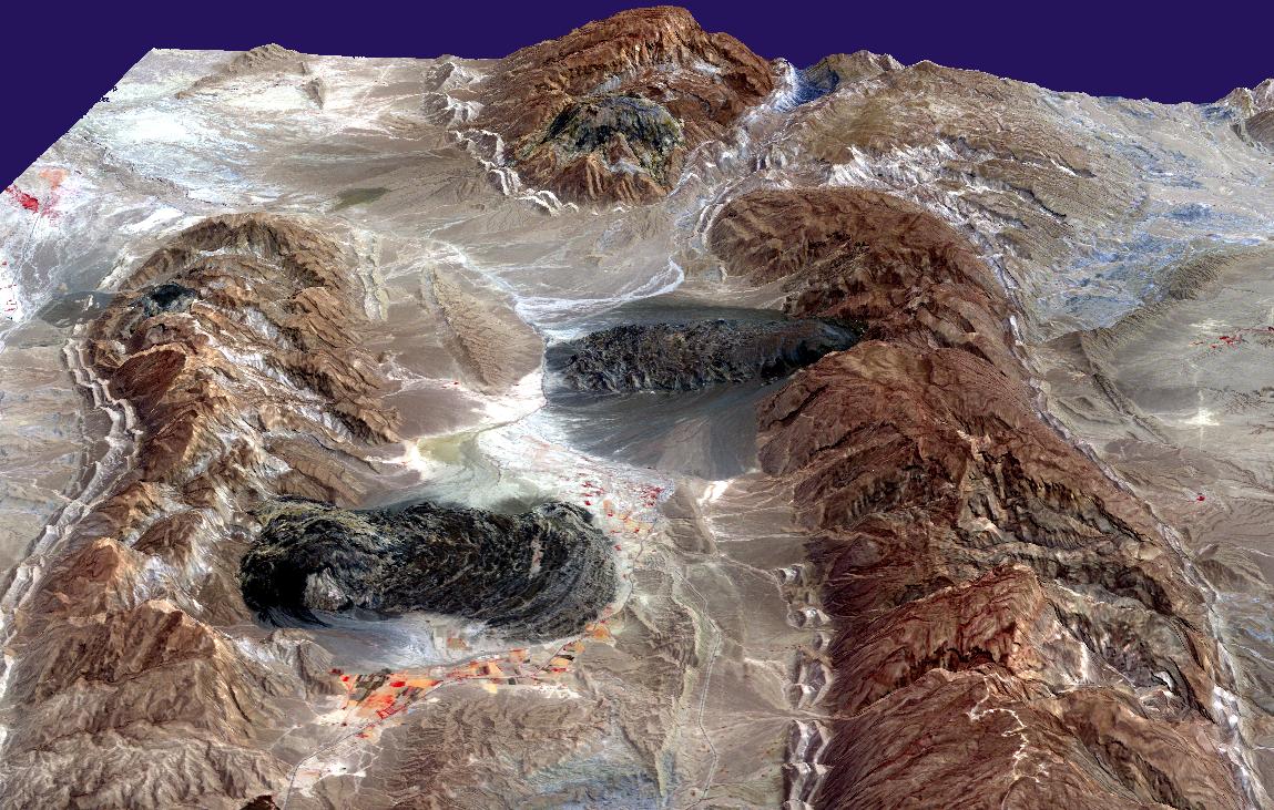
| 描述 | Satellite imagery of salt domes and salt glaciers, visible as darkish irregular patches, Zagros Mountains, southern Iran, near Karmowstaj. Gravity has caused the salt to flow like glaciers into adjacent valleys. The resulting tongue-shaped bodies are more than 5 kilometers long, with repeating bow-shaped ridges separated by crevasse-like gullies and with steep sides and fronts. The darker tones are due to clays brought up with the salt, as well as the probable accumulation of airborne dust. This Aster perspective view was created by draping a band 3-2-1 (RGB) image over an ASTER-derived Digital Elevation Model (2x vertical exaggeration). |
| 日期 | |
| 来源 | http://earthobservatory.nasa.gov/IOTD/view.php?id=4168 |
| 作者 | NASA/GSFC/MITI/ERSDAC/JAROS, and U.S./Japan ASTER Science Team |
| 授权 (二次使用本文件) |
US government, public domain |
许可协议
| 本文件完全由NASA创作,在美国属于公有领域。根据NASA的版权方针,NASA的材料除非另有声明否则不受版权保护。(参见Template:PD-USGov/zh、NASA版权方针页面或JPL图片使用方针。) | ||
 |
警告:
|
文件历史
点击某个日期/时间查看对应时刻的文件。
| 日期/时间 | 缩略图 | 大小 | 用户 | 备注 | |
|---|---|---|---|---|---|
| 当前 | 2006年4月27日 (四) 16:49 | | 1,149 × 731(231 KB) | Holly Cheng | {{Information | Description=Satellite imagery of w:salt domes and w:salt glaciers in the w:Zagros Mountains of southern Iran. This w:ASTER perspective view was created by draping a band 3-2-1 (RGB) image over an ASTER-derived Digital Eleva |
文件用途
没有页面链接到本图像。
全域文件用途
以下其他wiki使用此文件:
- ar.wikipedia.org上的用途
- ast.wikipedia.org上的用途
- bs.wikipedia.org上的用途
- ca.wikipedia.org上的用途
- cs.wikipedia.org上的用途
- de.wikipedia.org上的用途
- en.wikipedia.org上的用途
- es.wikipedia.org上的用途
- fa.wikipedia.org上的用途
- fr.wikipedia.org上的用途
- hr.wikipedia.org上的用途
- it.wikipedia.org上的用途
- ja.wikipedia.org上的用途
- ru.wikipedia.org上的用途
- sh.wikipedia.org上的用途
- sr.wikipedia.org上的用途
- uk.wikipedia.org上的用途