
File:Serrasalmus distribution map.svg

此SVG文件的PNG预览的大小:429 × 599像素。 其他分辨率:172 × 240像素 | 343 × 480像素 | 550 × 768像素 | 733 × 1,024像素 | 1,466 × 2,048像素 | 1,022 × 1,428像素。
原始文件 (SVG文件,尺寸为1,022 × 1,428像素,文件大小:1.06 MB)
| 描述 |
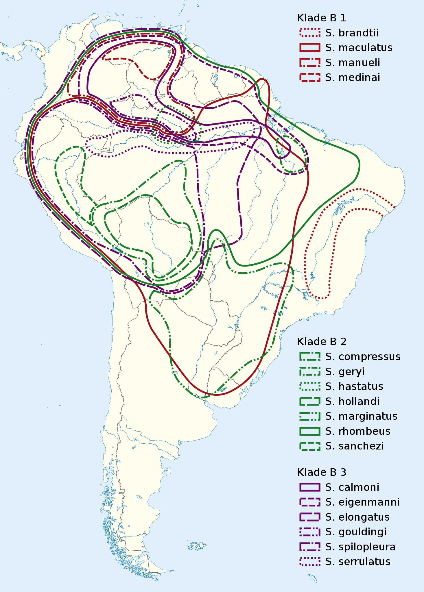
Deutsch: Verbreitungskarte Piranhas
English: Serrasalmus distribution map |
|
| 日期 | (UTC) | |
| 来源 |
|
|
| 作者 |
|
|
| 授权 (二次使用本文件) |
本文件采用知识共享署名-相同方式共享 3.0 德国许可协议授权。
 本文件采用知识共享署名-相同方式共享 3.0 未本地化版本许可协议授权。
|

原始上传日志
This image is a derivative work of the following images:
- File:South_America_laea_location_map.svg licensed with Cc-by-sa-3.0, GFDL
- 2010-11-27T12:48:20Z Uwe Dedering 1181x1732 (3103940 Bytes) {{Information |Description={{en|1= Location map of SouthAmerica. * Projection: Lambert azimuthal equal-area projection. * Area of interest: :* N: 25.0° N :* S: -60.0° N :* W: -90.0° E :* E: -30.0° E * Projection center: :
Uploaded with derivativeFX

|
|
文件历史
点击某个日期/时间查看对应时刻的文件。
| 日期/时间 | 缩略图 | 大小 | 用户 | 备注 | |
|---|---|---|---|---|---|
| 当前 | 2011年3月4日 (五) 21:43 | | 1,022 × 1,428(1.06 MB) | NordNordWest | {{Information |Description={{de|Verbreitungskarte Piranhas}} {{en|''Serrasalmus'' distribution map}} |Source=*File:South_America_laea_location_map.svg *N. Hubert, F. Duponchelle, J. Nuñez, C. Garcia-Davila, D. P |
文件用途
以下页面使用本文件:
全域文件用途
以下其他wiki使用此文件:
- arz.wikipedia.org上的用途
- be.wikipedia.org上的用途
- bg.wikipedia.org上的用途
- ca.wikipedia.org上的用途
- de.wikipedia.org上的用途
- es.wikipedia.org上的用途
- fr.wikipedia.org上的用途
- hsb.wikipedia.org上的用途
- hu.wikipedia.org上的用途
- it.wikipedia.org上的用途
- pl.wikipedia.org上的用途
- pt.wikipedia.org上的用途
- ru.wikipedia.org上的用途
- sv.wikipedia.org上的用途
- th.wikipedia.org上的用途
- uk.wikipedia.org上的用途
- www.wikidata.org上的用途