
File:Somaliland. Anglo-Italian Boundary Commission 1929-1930. Index to Field sheets etc. War Office ledger (WOOS-33-1).jpg

本预览的尺寸:586 × 600像素。 其他分辨率:234 × 240像素 | 469 × 480像素 | 750 × 768像素 | 1,000 × 1,024像素 | 2,001 × 2,048像素 | 5,405 × 5,533像素。
原始文件 (5,405 × 5,533像素,文件大小:24.95 MB,MIME类型:image/jpeg)
摘要
; ;
| 标题 |
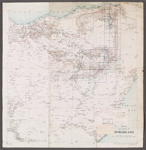
Somaliland. Anglo-Italian Boundary Commission 1929-1930.' 'Index to Field sheets etc.' - War Office ledger (WOOS/33/1) |
|||||||||||||||||||||||
| 描写 |
Graphic index portraying extent of Boundary Survey (air photos), British field sheets and Italian field sheets, as filed at WOOS/33/2. Information added in manuscript to lithographed base map. Legend affixed to map face.Base map is G.S.G.S. 1781, revised October 1906 as T.S.G.S. 1781, titled 'Map of a portion of Somaliland' and filed at Maps MOD IDWO 1781. Portrays hydrology, relief by form lines and spot heights, roads and tracks, settlements, water sources, international boundaries and place names. Creation start date derived from earliest use of designation 'G.S.G.S.' |
|||||||||||||||||||||||
| British Library Shelfmark | WOOS/33/1 | |||||||||||||||||||||||
| Locations Depicted | British Somaliland, Africa, 1884-1960 Italian Somaliland, Africa, 1889-1936 | |||||||||||||||||||||||
| Centre Point Coordinates | 8.0000,47.0000 | |||||||||||||||||||||||
| 日期 | [1909]-1930 | |||||||||||||||||||||||
| 来源 |
|
|||||||||||||||||||||||
| 創作作者 |
Anglo-Italian Somaliland Boundary Commission, 1929-1930, Publisher Phipps, John Faviell, 1894-1964, army officer, Surveyor Stafford, John Howard, fl 1918-1966, army officer, Surveyor Taylor, Richard Harold Redvers, 1900-1975, army officer and artist, Surveyor |
|||||||||||||||||||||||
| 授权 (二次使用本文件) |
|
|||||||||||||||||||||||
| Geotemporal data | ||||||||||||||||||||||||
| 地图位置 | Somaliland | |||||||||||||||||||||||
| 比例尺 | Scale 1:1,000,000 | |||||||||||||||||||||||
| 边框 |
|
|||||||||||||||||||||||
| 地理参考 | 如果不适当,请设置 warp_status = skip 为隐藏。 | |||||||||||||||||||||||
| Archival data | ||||||||||||||||||||||||
| 館藏 |
|
|||||||||||||||||||||||
| 尺寸 | 74 x 73cm | |||||||||||||||||||||||
| 表现形式 | Printed, with manuscript additions in coloured ink, watercolour and pencil | |||||||||||||||||||||||
| 备注 | For more information please see the British Library’s Collection Guide to the War Office Archive. | |||||||||||||||||||||||

_(St_Edwards_Crown).svg)


.jpg?uselang=zh)
.jpg?uselang=zh)
.jpg?action=history&uselang=zh)
.jpg)
.jpg¶ms=11.0000_N_44.0000_E_)
.jpg¶ms=11.0000_N_50.0000_E_)
.jpg¶ms=5.0000_N_44.0000_E_)
.jpg¶ms=5.0000_N_50.0000_E_)
文件历史
点击某个日期/时间查看对应时刻的文件。
| 日期/时间 | 缩略图 | 大小 | 用户 | 备注 | |
|---|---|---|---|---|---|
| 当前 | 2018年3月28日 (三) 12:09 | | 5,405 × 5,533(24.95 MB) | Ndalyrose | GWToolset: Creating mediafile for Ndalyrose. |
文件用途
没有页面链接到本图像。
全域文件用途
以下其他wiki使用此文件:
- ar.wikipedia.org上的用途
- en.wikipedia.org上的用途
- id.wikipedia.org上的用途
- so.wikipedia.org上的用途
.jpg)