
File:South Africa Western Cape relief location map.svg

此SVG文件的PNG预览的大小:749 × 600像素。 其他分辨率:300 × 240像素 | 600 × 480像素 | 959 × 768像素 | 1,279 × 1,024像素 | 2,558 × 2,048像素 | 1,214 × 972像素。
原始文件 (SVG文件,尺寸为1,214 × 972像素,文件大小:1.98 MB)
| 描述 |
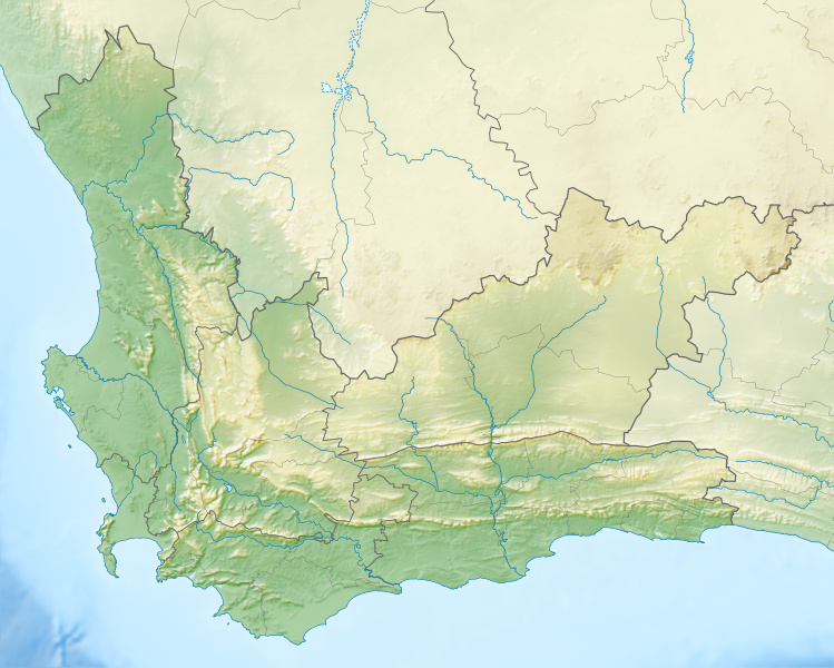
English: Relief location map of the Western Cape
Equirectangular projection, N/S stretching 118%. Geographic limits of the map:
|
| 日期 | |
| 来源 |
|
| 作者 | Htonl |
| 授权 (二次使用本文件) |
我,本作品著作权人,特此采用以下许可协议发表本作品: 本文件采用知识共享署名-相同方式共享 3.0 未本地化版本许可协议授权。
|
| 其他版本 | File:South Africa Western Cape location map.svg |
文件历史
点击某个日期/时间查看对应时刻的文件。
| 日期/时间 | 缩略图 | 大小 | 用户 | 备注 | |
|---|---|---|---|---|---|
| 当前 | 2013年1月4日 (五) 19:44 | | 1,214 × 972(1.98 MB) | Htonl | {{Information |Description ={{en|1=Relief location map of the Western Cape Equirectangular projection, N/S stretching 118%. Geographic limits of the map: * N: 30.25° S * S: 35.0° S * W: 17.5° E * E: 24.5° E}} |Source ... |
文件用途
以下2个页面使用本文件:
全域文件用途
以下其他wiki使用此文件:
- ar.wikipedia.org上的用途
- ban.wikipedia.org上的用途
- be.wikipedia.org上的用途
- bg.wikipedia.org上的用途
- ceb.wikipedia.org上的用途
- de.wikipedia.org上的用途
- Tafelbucht
- Boulders Beach
- Saldanha Bay
- Montagu-Pass
- Wikipedia:Kartenwerkstatt/Positionskarten/Afrika
- Dyer Island (Südafrika)
- False Bay
- Vorlage:Positionskarte Südafrika Westkap
- Duiker Island
- Dassen Island
- Benutzer:Olga Ernst/Walker Bay (Südafrika)
- Walker Bay (Südafrika)
- Matroosberg
- Still Bay
- Sankt-Helena-Bucht
- Bergwerk Steenkampskraal
- en.wikipedia.org上的用途
- Stellenbosch
- Cederberg
- False Bay
- Chapman's Peak
- Blombos Cave
- Dassen Island
- Rondevlei Nature Reserve
- Seal Island, South Africa
- Marloth Nature Reserve
- Karoo National Park
- Dimension Data Pro-Am
- BOS 400
- De Hoop Nature Reserve
- Duiker Island
- Hex River Mountains
- Arniston (East Indiaman)
- Boosmansbos Wilderness Area
- Johanna (East Indiaman)
- Module:Location map/data/South Africa Western Cape/doc
- Coca-Cola Charity Championship
- Grootrivier Pass
- Akkedisberg Pass
- Attakwaskloof Pass
查看此文件的更多全域用途。