
File:Spreading ridges volcanoes map-en.svg

此SVG文件的PNG预览的大小:800 × 402像素。 其他分辨率:320 × 161像素 | 640 × 322像素 | 1,024 × 515像素 | 1,280 × 643像素 | 2,560 × 1,286像素 | 4,995 × 2,510像素。
原始文件 (SVG文件,尺寸为4,995 × 2,510像素,文件大小:1.29 MB)
摘要
| 描述 |
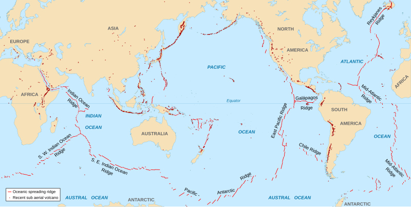
English: World map in English showing the divergent plate boundaries (OSR – Oceanic Spreading Ridges) and recent sub aerial volcanoes.
Français : Carte en anglais des dorsales océaniques et volcans terrestres récents. |
||
| 日期 | 2006-10, upgraded 2015-09 | ||
| 来源 |
|
||
| 作者 | Eric Gaba (Sting - fr:Sting) | ||
| 授权 (二次使用本文件) |
|
||
| 其他版本 |
|

The Data source link above is now dead. Potentially active/active volcanoes appear to have been mapped if erupted within about last 10,000 odd years with an accuracy of about 50 km (31 mi) onto current basemap. Some active volcanoes are not shown and divergent plate boundaries may have inaccuracies. The map has not been updated since 2015.
许可协议
我,本作品著作权人,特此采用以下许可协议发表本作品:
本文件采用知识共享署名-相同方式共享 2.5 通用许可协议授权。
- 您可以自由地:
- 共享 – 复制、发行并传播本作品
- 修改 – 改编作品
- 惟须遵守下列条件:
- 署名 – 您必须对作品进行署名,提供授权条款的链接,并说明是否对原始内容进行了更改。您可以用任何合理的方式来署名,但不得以任何方式表明许可人认可您或您的使用。
- 相同方式共享 – 如果您再混合、转换或者基于本作品进行创作,您必须以与原先许可协议相同或相兼容的许可协议分发您贡献的作品。
文件历史
点击某个日期/时间查看对应时刻的文件。
| 日期/时间 | 缩略图 | 大小 | 用户 | 备注 | |
|---|---|---|---|---|---|
| 当前 | 2015年9月6日 (日) 18:51 | | 4,995 × 2,510(1.29 MB) | Sting | New background map using NGDC WCL data |
| 2007年11月11日 (日) 12:58 |  | 5,000 × 2,525(913 KB) | Walké | petite correction | |
| 2006年10月23日 (一) 22:10 |  | 5,000 × 2,525(913 KB) | Sting | OCR name correction; + Red Sea OCR; + continent names | |
| 2006年10月23日 (一) 15:25 |  | 5,000 × 2,525(898 KB) | Sting | {{Information| |Description=World map in English showing the divergent plate boundaries (OSR – Oceanic Spreading Ridges) and recent sub aerial volcanoes |Source= '''Background map (modified) :''' Image:Tectonic plates (empty).svg created by [[User: |
.svg)
文件用途
没有页面链接到本图像。
全域文件用途
以下其他wiki使用此文件:
- af.wikipedia.org上的用途
- as.wikipedia.org上的用途
- en.wikipedia.org上的用途
- en.wikiquote.org上的用途
- fi.wikipedia.org上的用途
- fr.wikipedia.org上的用途
- gu.wikipedia.org上的用途
- it.wikibooks.org上的用途
- ja.wikipedia.org上的用途
- ki.wikipedia.org上的用途
- lij.wikipedia.org上的用途
- mk.wikipedia.org上的用途
- ml.wikipedia.org上的用途
- mwl.wikipedia.org上的用途
- pnb.wikipedia.org上的用途
- pt.wikipedia.org上的用途
- rm.wikipedia.org上的用途
- sr.wikipedia.org上的用途
- ta.wikipedia.org上的用途
- te.wikipedia.org上的用途
- tl.wikipedia.org上的用途
- tr.wikipedia.org上的用途
- tt.wikipedia.org上的用途
- tyv.wikipedia.org上的用途
- ur.wikipedia.org上的用途
- vi.wikipedia.org上的用途
- xh.wikipedia.org上的用途