
File:Stellardiagram-Zhengho.jpg
本预览的尺寸:456 × 599像素。 其他分辨率:183 × 240像素 | 365 × 480像素 | 584 × 768像素 | 779 × 1,024像素 | 1,385 × 1,820像素。
原始文件 (1,385 × 1,820像素,文件大小:1.74 MB,MIME类型:image/jpeg)
摘要
| 作者 |
The author is unknown, but the charts were derived from works by Zheng He's expeditionary navigators during the early 15th century |
| 描述 |
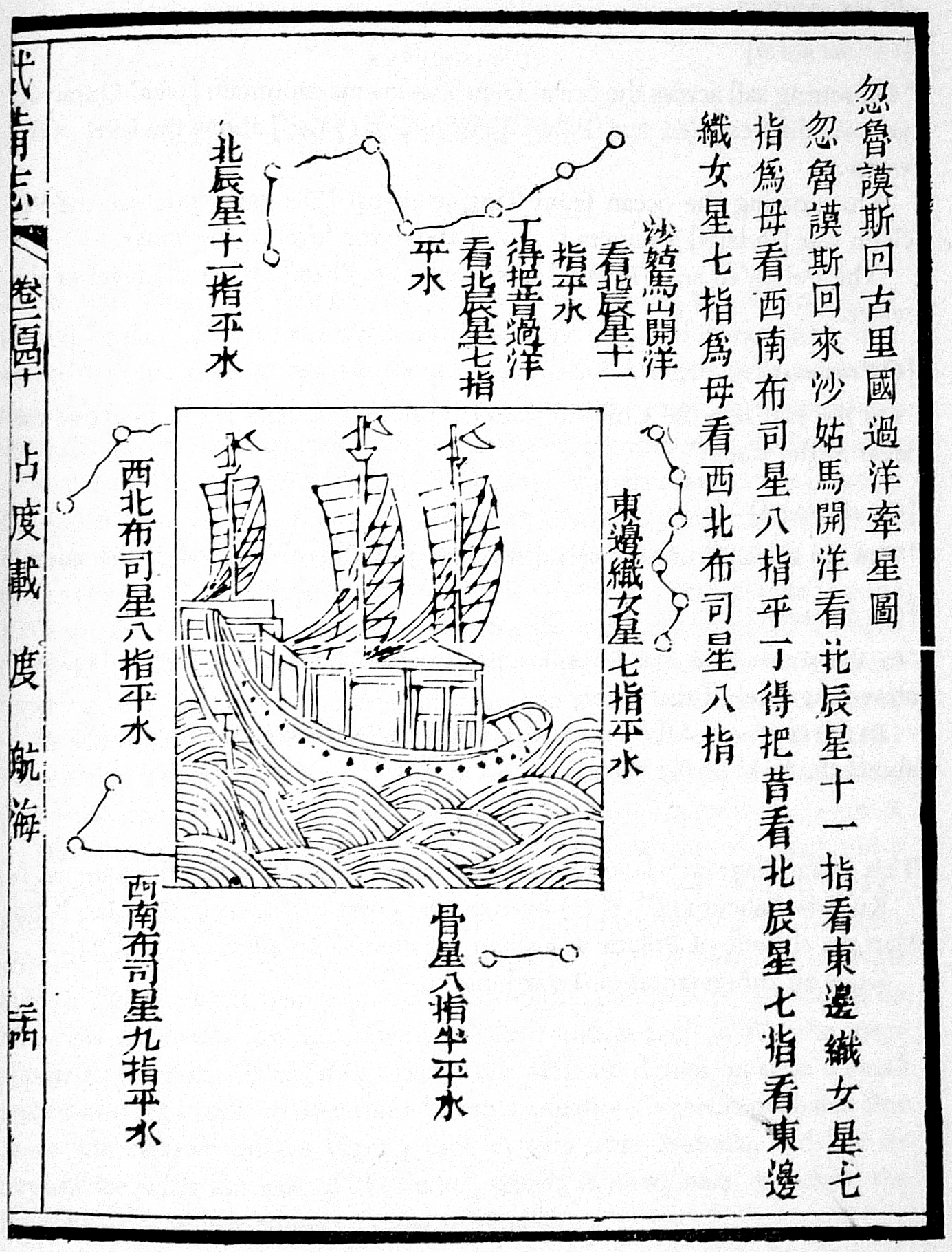
This navigational chart is one of the four stellar diagrams included in the Wubei Zhi, published in circa 1628. It appears in chapter 240, folio 24 r. The chart specifies the guiding stars enroute from Hormuz to Calicut. |
| 来源/摄影师 | Not given by uploader |
| 其他版本 |
|
| Reference | Mills, J.V.G. (1970). Ying-yai Sheng-lan: 'The Overall Survey of the Ocean's Shores' [1433]. pp. 335–346. |

许可协议
|
本作品在其来源国以及其他著作权期限是作者逝世后100年或以下的国家和地区属于公有领域。 | |
| 本文件已被确认为免除已知的著作权法限制(包括所有相关权利)。 | |
文件历史
点击某个日期/时间查看对应时刻的文件。
| 日期/时间 | 缩略图 | 大小 | 用户 | 备注 | |
|---|---|---|---|---|---|
| 当前 | 2015年8月1日 (六) 19:32 | | 1,385 × 1,820(1.74 MB) | Hzh | clearer image |
| 2005年12月8日 (四) 15:55 |  | 588 × 800(78 KB) | Gisling | Admiral Zheng Ho's stellar navigation diagram |
文件用途
全域文件用途
以下其他wiki使用此文件:
- af.wikipedia.org上的用途
- ar.wikipedia.org上的用途
- ca.wikipedia.org上的用途
- cs.wikipedia.org上的用途
- el.wikipedia.org上的用途
- en.wikipedia.org上的用途
- es.wikipedia.org上的用途
- fr.wikipedia.org上的用途
- it.wikipedia.org上的用途
- ja.wikipedia.org上的用途
- pt.wikipedia.org上的用途
- ru.wikipedia.org上的用途
- sl.wikipedia.org上的用途
- test.wikipedia.org上的用途
- te.wikipedia.org上的用途
- uk.wikipedia.org上的用途
- vi.wikipedia.org上的用途