
File:Stillwater Minnesota waterfront aerial view.jpg

本预览的尺寸:749 × 600像素。 其他分辨率:300 × 240像素 | 600 × 480像素 | 959 × 768像素 | 1,279 × 1,024像素 | 1,500 × 1,201像素。
原始文件 (1,500 × 1,201像素,文件大小:1.05 MB,MIME类型:image/jpeg)
| 描述 |
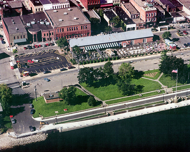
English: Aerial view of part of the waterfront section of Stillwater, Minnesota, USA, on the St. Croix River. View is to the west. The U.S. Army Corps of Engineers has constructed a floodwall along the waterfront. |
|||
| 日期 | 摄于1999年8月24日 | |||
| 来源 |
U.S. Army Corps of Engineers Digital Visual Library Image page Image description page Digital Visual Library home page |
|||
| 作者 | U.S. Army Corps of Engineers, photographer not specified or unknown | |||
| 授权 (二次使用本文件) |
|
|||
| 图中地点 | Stillwater, Washington County, Minnesota, USA |
| 相机位置 | | 在以下服务上查看本图像和附近其他图像: OpenStreetMap |
|---|
文件历史
点击某个日期/时间查看对应时刻的文件。
| 日期/时间 | 缩略图 | 大小 | 用户 | 备注 | |
|---|---|---|---|---|---|
| 当前 | 2007年4月7日 (六) 00:08 | | 1,500 × 1,201(1.05 MB) | DanMS | {{Information | Description = {{en|Aerial view of part of the waterfront section of Stillwater, Minnesota, USA, on the St. Croix River. View is to the west. The U.S. Army Corps of Engineers has constructed a floodwall along the waterfront.}} | |
文件用途
以下页面使用本文件:
全域文件用途
以下其他wiki使用此文件:
- ar.wikipedia.org上的用途
- arz.wikipedia.org上的用途
- azb.wikipedia.org上的用途
- ca.wikipedia.org上的用途
- ceb.wikipedia.org上的用途
- ce.wikipedia.org上的用途
- dag.wikipedia.org上的用途
- en.wikipedia.org上的用途
- en.wikivoyage.org上的用途
- es.wikipedia.org上的用途
- eu.wikipedia.org上的用途
- fa.wikipedia.org上的用途
- fi.wikipedia.org上的用途
- fr.wikipedia.org上的用途
- he.wikivoyage.org上的用途
- ht.wikipedia.org上的用途
- hu.wikipedia.org上的用途
- ko.wikipedia.org上的用途
- ky.wikipedia.org上的用途
- lld.wikipedia.org上的用途
- no.wikipedia.org上的用途
- pl.wikipedia.org上的用途
- ru.wikipedia.org上的用途
- sh.wikipedia.org上的用途
- sr.wikipedia.org上的用途
- sv.wikipedia.org上的用途
- tr.wikipedia.org上的用途
- tt.wikipedia.org上的用途
- uk.wikipedia.org上的用途
- uz.wikipedia.org上的用途
- vi.wikipedia.org上的用途
- vo.wikipedia.org上的用途
- www.wikidata.org上的用途
- zh-min-nan.wikipedia.org上的用途