
File:Stonehenge World Heritage Site map 2.svg

此SVG文件的PNG预览的大小:497 × 600像素。 其他分辨率:199 × 240像素 | 398 × 480像素 | 636 × 768像素 | 848 × 1,024像素 | 1,696 × 2,048像素 | 1,438 × 1,736像素。
原始文件 (SVG文件,尺寸为1,438 × 1,736像素,文件大小:1.57 MB)
摘要
| 描述 |
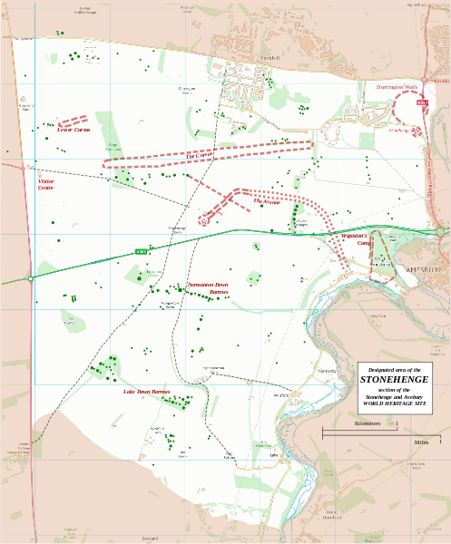
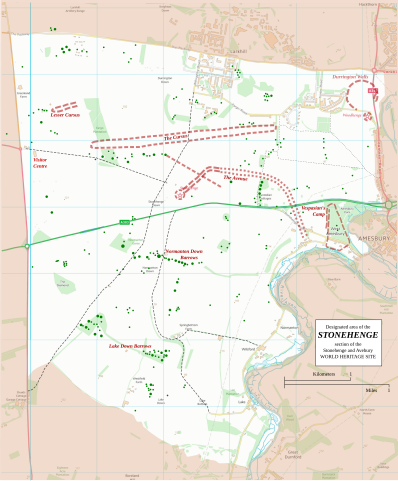
English: Boundary and key sites on the Avebury section of the Stonehenge, Avebury and Associated Sites World Heritage Site |
| 日期 | |
| 来源 | OS Open Data with additional material cited at World Heritage Site list No 373 |
| 作者 | RobinLeicester building on OS OpenData VextorMap District Raster files |
| 相机位置 | | 在以下服务上查看本图像和附近其他图像: OpenStreetMap |
|---|
Principal monuments and earthworks are shown in Red. Barrows are indicated by green dots.
许可协议
This file is licensed by the Ordnance Survey of the United Kingdom under their OS OpenData License
In short: you are free to distribute and modify the file as long as you attribute (including year), the Ordnance Survey. 署名: Contains Ordnance Survey data © Crown copyright and database right (year) Note: Derivative works can be licensed under any Creative Commons Attribution 3.0 Licence. |
_(St_Edwards_Crown).svg)
|
This file is licensed under the United Kingdom Open Government Licence v3.0. |
See also: Meta for information on usage on Wikimedia wikis.
|
文件历史
点击某个日期/时间查看对应时刻的文件。
| 日期/时间 | 缩略图 | 大小 | 用户 | 备注 | |
|---|---|---|---|---|---|
| 当前 | 2015年1月13日 (二) 22:36 | | 1,438 × 1,736(1.57 MB) | RobinLeicester | User created page with UploadWizard |
文件用途
以下页面使用本文件:
全域文件用途
以下其他wiki使用此文件:
- cs.wikipedia.org上的用途
- de.wikipedia.org上的用途
- en.wikipedia.org上的用途
- fi.wikipedia.org上的用途
- fr.wikipedia.org上的用途
- fr.wikivoyage.org上的用途
- ja.wikipedia.org上的用途
- kw.wikipedia.org上的用途
- nl.wikipedia.org上的用途
- ru.wikipedia.org上的用途
- simple.wikipedia.org上的用途
- sl.wikipedia.org上的用途
- ur.wikipedia.org上的用途