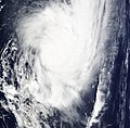
File:Tropical Cyclone Joni 2009-03-12.jpg

页面内容不支持其他语言。
這個文件來自維基共享資源
维基百科,自由的百科全书

原始文件(6,400 × 8,000像素,文件大小:7.21 MB,MIME类型:image/jpeg


摘要

描述
English: Late on March 10, a strong tropical disturbance formed about 770km (475 miles) west of Tahiti. Later that day multispectrial imagery had shown a well defined low level circulation center with formative convective banding wrapping well in to the center. Because of this, the JTWC issued a Tropical Cyclone Formation Alert on the developing system. Late the next day, RSMC Nadi designated the disturbance as Tropical Depression 11F and started to issue gale warnings for the Southern Cook Islands. Early on March 12, the JTWC designated the disturbance as Tropical Cyclone 20P, whilst later that day RSMC Nadi upgraded the Depression to a Tropical Cyclone and named it Joni. The Category Two Tropical Cyclone moved south of 25S late on March 12th.
日期
来源 http://rapidfire.sci.gsfc.nasa.gov/realtime/single.php?2009071/crefl1_143.A2009071210000-2009071210500.4km.jpg
作者 NASA
授权
(二次使用本文件)
Public domain

许可协议

Public domain 本文件完全由NASA创作,在美国属于公有领域。根据NASA的版权方针,NASA的材料除非另有声明否则不受版权保护。(参见Template:PD-USGov/zhNASA版权方针页面JPL图片使用方针。)
警告:

说明

添加一行文字以描述该文件所表现的内容

此文件中描述的项目

描繪內容

文件历史

点击某个日期/时间查看对应时刻的文件。

日期/时间缩⁠略⁠图大小用户备注
当前2020年10月20日 (二) 00:122020年10月20日 (二) 00:12版本的缩略图6,400 × 8,000(7.21 MB)FleurDeOdile250m
2017年8月10日 (四) 18:492017年8月10日 (四) 18:49版本的缩略图2,544 × 3,736(1.42 MB)FleurDeOdileflattened
2009年3月13日 (五) 22:452009年3月13日 (五) 22:45版本的缩略图2,708 × 2,653(1.38 MB)HurricaneSpin{{Information |Description={{en|1=Late on March 10, a strong tropical disturbance formed about 770km (475 miles) west of Tahiti. Later that day multispectrial imagery had shown a well defined low level circulation center with formative convective banding

以下页面使用本文件:

全域文件用途

以下其他wiki使用此文件: