
File:United Arab States (1958-1961).png

本预览的尺寸:800 × 409像素。 其他分辨率:320 × 164像素 | 821 × 420像素。
原始文件 (821 × 420像素,文件大小:30 KB,MIME类型:image/png)
.png?uselang=zh)
.png?uselang=zh)
.png?action=history&uselang=zh)
.png)
摘要
| 描述 |
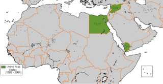
English: United Arab States, 1958 to 1961 |
| 日期 | 2008年1月17日 (原始上传日期) |
| 来源 |
self-made) Further moved from .gif to .png |
| 作者 | 英语维基百科的Arab League |
许可协议
英语维基百科的Arab League,本作品著作权人,特此采用以下许可协议发表本作品:

|
已授权您依据自由软件基金会发行的无固定段落及封面封底文字(Invariant Sections, Front-Cover Texts, and Back-Cover Texts)的GNU自由文件许可协议1.2版或任意后续版本的条款,复制、传播和/或修改本文件。该协议的副本请见“GNU Free Documentation License”。 |
本文件采用知识共享署名 3.0 未本地化版本许可协议授权。
署名: 英语维基百科的Arab League
- 您可以自由地:
- 共享 – 复制、发行并传播本作品
- 修改 – 改编作品
- 惟须遵守下列条件:
- 署名 – 您必须对作品进行署名,提供授权条款的链接,并说明是否对原始内容进行了更改。您可以用任何合理的方式来署名,但不得以任何方式表明许可人认可您或您的使用。
您可以选择您需要的许可协议。
原始上传日志
原始描述頁面位於這裡。下列使用者名稱均來自en.wikipedia。
- 2008-01-17 16:33 Arab League 821×420×8 (16395 bytes) {{Information |Description= |Source=self-made |Date= |Location= |Author= |Permission= |other_versions= }}
文件历史
点击某个日期/时间查看对应时刻的文件。
| 日期/时间 | 缩略图 | 大小 | 用户 | 备注 | |
|---|---|---|---|---|---|
| 当前 | 2018年3月9日 (五) 14:32 | | 821 × 420(30 KB) | Maphobbyist | Recheck |
| 2018年3月9日 (五) 14:24 |  | 821 × 420(30 KB) | Maphobbyist | Check | |
| 2018年2月1日 (四) 21:41 |  | 821 × 420(30 KB) | Maphobbyist | Partial revert: Removed South Sudan and Eritrea, because they were not independent at the time. This is a historical map. | |
| 2018年2月1日 (四) 21:36 |  | 821 × 420(31 KB) | Maphobbyist | Modern borders of Turkey, because Hatay Province is part of Turkey since 1939 and borders of South Sudan which became independent in 2011. | |
| 2010年7月2日 (五) 23:49 |  | 821 × 420(17 KB) | Dcoetzee | Remove watermark | |
| 2010年1月4日 (一) 06:57 |  | 821 × 420(15 KB) | Reisio | {{Information |Description={{en|United Arab States, 1958 to 1961}} |Source=Transferred from [http://en.wikipedia.org en.wikipedia]<br/> (Original text : ''self-made'')<br/>Further moved from .gif to .png |Date=2008-01-17 (original |
文件用途
没有页面链接到本图像。
全域文件用途
以下其他wiki使用此文件:
- ar.wikipedia.org上的用途
- azb.wikipedia.org上的用途
- bn.wikipedia.org上的用途
- bs.wikipedia.org上的用途
- da.wikipedia.org上的用途
- de.wikipedia.org上的用途
- el.wikipedia.org上的用途
- en.wikipedia.org上的用途
- fa.wikipedia.org上的用途
- fr.wikipedia.org上的用途
- hu.wikipedia.org上的用途
- id.wikipedia.org上的用途
- it.wikipedia.org上的用途
- ja.wikipedia.org上的用途
- ka.wikipedia.org上的用途
- ko.wikipedia.org上的用途
- mk.wikipedia.org上的用途
- ms.wikipedia.org上的用途
- nl.wikipedia.org上的用途
- pl.wikipedia.org上的用途
- pnb.wikipedia.org上的用途
- pt.wikipedia.org上的用途
- ru.wikipedia.org上的用途
- sr.wikipedia.org上的用途
- th.wikipedia.org上的用途
- uk.wikipedia.org上的用途
- ur.wikipedia.org上的用途
- vi.wikipedia.org上的用途
.png)