Template:Infobox earthquake/new
| 此模板使用Lua语言: |
本模板对应英文维基版本。
用法[编辑]
{{Infobox earthquake/new
 | name        =
 | image       = <!-- file name only -->
 | alt         =
 | caption     =
 | map         = <!-- file name only -->
 | map_alt     =
 | map_caption =
 | pushpin_map = <!-- as per Template:Location map -->
 | map2        = <!-- as per Template:Location map+ -->
 | pre-1900    = <!-- Set to 'yes' if before 1900-01-01. Relaxes timestamp format -->
 | timestamp   = <!-- UTC date/time ("origin time") in yyyy-mm-dd hh:mm:[ss] format -->
 | isc-event   = <!-- ISC event id, or "n/a". SEE BELOW -->
 | anss-url    = <!-- Url (or fragment) of USGS-ANSS event page, or "n/a". SEE BELOW. -->
 | local-date  = <!-- Local date of area most affected: '{{Start date|YYYY|MM|DD}}' -->
 | local-time  = <!-- From newspapers? Include timezone -->
 | duration    =
 | magnitude   = <!-- 'N.N {{M|?|link=y}}'. Get proper code from source. See below. -->
 | depth       = <!-- '{{convert|NNN|km|mi|0|abbr=on}}' -->
 | location    = <!-- '{{coord|XXXXX|region:XX_type:event|display=inline,title}}' -->
 | fault       =
 | type        =
 | affected    =
 | damages     = <!-- cost/extent of property damage -->
 | intensity   =
 | pga         = <!-- NN ''[[Peak ground acceleration|g]]'' -->
 | pgv         = <!-- NN cm/s -->
 | tsunami     =
 | landslide   =
 | foreshocks  =
 | aftershocks =
 | casualties  =
 | engvar      = <!-- follow article: =en-UK will show 'Epicentre' -->
 | citations    =
}}
示例[编辑]
 Piles of rubble, one week after the shock | |
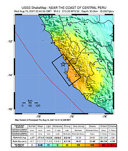
 Map of the Peru coastline, showing location and strength of quake. Star marks epicenter. | |
| UTC时间 | 2007-08-15 23:40:58 |
|---|---|
| ISC事件 | 1280473 |
| USGS-ANSS | 目录 |
| 当地日期 | 2007年8月15日 |
| 当地时间 | 18:40 |
| 震级 | 8.0 MW |
| 震源深度 | 39 km(24 mi) |
| 震中 | 13°21′14″S 76°30′32″W / 13.354°S 76.509°W坐标:13°21′14″S 76°30′32″W / 13.354°S 76.509°W |
| 断层 | Nazca-South American plate |
| 影响地区 | Ica Region (Pisco, Ica and Chincha Alta) and Lima Region (San Vicente de Cañete) |
| 海啸 | flooded part of Lima's Costa Verde highway, and much of Pisco's shore |
| 伤亡 | 519 confirmed dead, 1,366 injured |
{{Infobox earthquake/new
 | name        = 2007 Peru earthquake
 | image       = 40 - Tremblement de terre - Août 2007.JPG
 | alt         = Picture showing earthquake damage.
 | caption     = Piles of rubble, one week after the shock
 | map         = Peru Quake Aug 15-2007.jpg
 | map_alt     = Map of the Peru coastline, showing location and strength of quake.
 | map_caption = Map of the Peru coastline, showing location and strength of quake. Star marks [[epicenter]].
 | timestamp   = 2007-08-15 23:40:37
 | isc-event   = 1280473
 | anss-url    = usp000fjta
 | local-date  = {{Start date|2007|8|15}}
 | local-time  = 18:40
 | magnitude   = 8.0 {{M|w|link=y}}
 | depth       = {{convert|39|km|mi|abbr=on}}
 | location    = {{coord|13.354|S|76.509|W|region:PE_type:event|display=inline,title}}
 | fault       = [[Nazca Plate|Nazca]]-[[South American Plate|South American plate]]
 | affected    = [[Ica Region]] ([[Pisco, Peru|Pisco]], [[Ica (city)|Ica]] and [[Chincha Alta]]) and [[Lima Region]] ([[San Vicente de Cañete]])
 | tsunami     = flooded part of Lima's Costa Verde highway, and much of Pisco's shore
 | casualties  = 519 confirmed dead, 1,366 injured
}}
| 上述文档嵌入自Template:Infobox earthquake/new/doc。 (编辑 | 历史) 编者可以在本模板的沙盒 (创建 | 镜像)和测试样例 (创建)页面进行实验。 请在/doc子页面中添加分类。本模板的子页面。 |
