地獄之門水道
外观
62°40′20.3″S 61°10′46.4″W / 62.672306°S 61.179556°W


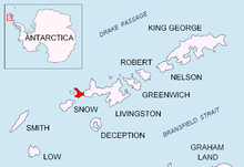
地獄之門水道(英語:Hell Gates)是一條狹窄(20米寬)的水道,位於拜爾斯半島的瓦爾迪姆岩與德維爾斯角之間,連接位在南極洲南設得蘭群島利文斯頓島西南末端的拉斯庫波里斯灣與奧索戈沃灣。這個名字的歷史可以追溯到大約1821年,由該地區早期從事海豹狩獵的人使用此名稱,因為這裡失去了許多生命和船隻[1]。
參考資料
[编辑]- Península Byers, Isla Livingston. Mapa topográfico a escala 1:25000. Madrid: Servicio Geográfico del Ejército, 1992.
- L.L. Ivanov et al., Antarctica: Livingston Island and Greenwich Island, South Shetland Islands (from English Strait to Morton Strait, with illustrations and ice-cover distribution), 1:100000 scale topographic map, Antarctic Place-names Commission of Bulgaria, Sofia, 2005
- L.L. Ivanov. Antarctica: Livingston Island and Greenwich, Robert, Snow and Smith Islands.(页面存档备份,存于互联网档案馆) Scale 1:120000 topographic map. Troyan: Manfred Wörner Foundation, 2009. ISBN 978-954-92032-6-4
參考文獻
[编辑]- ^ Hell Gates. Geographic Names Information System. United States Geological Survey. [2012-06-09].
![]() 本条目引用的公有领域材料来自美国地质调查局的文档《地獄之門水道》 (資料來自地名信息系统)。
本条目引用的公有领域材料来自美国地质调查局的文档《地獄之門水道》 (資料來自地名信息系统)。

