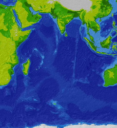
东经九十度洋脊
外观

东经九十度洋脊是印度洋的洋脊,位于北面的安达曼群岛和南面的印度洋东南海岭之间,全长约5,000公里,平均宽度200公里,北部和南部分别在4,320万年和8,180万年形成。[1]
参考资料
[编辑]- ^ Ramana, M.V.; T. Ramprasad; M. Desa; V. Subrahmanyam. Integrated geophysical studies over the 85°E ridge - Evaluation and interpretation. Visakha Science Journal. 2000, 4 (1): 45–56 [2017-12-07]. (原始内容存档于2021-01-24).
延伸阅读
[编辑]- Sager, William W. Cruise Report KNOX06RR R/V Roger Revelle 18 June to 6 August, 2007, Phuket to Singapore (PDF). Scripps Institution of Oceanography. 2007 [2017-12-07]. (原始内容存档 (PDF)于2016-03-04).
- Nobre Silva, I. G. Deciphering mantle source components in basalts from hotspot tracks and oceanic islands. University of British Columbia. 2011 [2017-12-07]. (原始内容存档于2012-03-31).
- Sager, W. W.; Paul, C.F.; Krishna, K.S.; Pringle, M.S.; Eisin, A.E.; Frey, F.A.; Rao, D.G.; Levchenko, O.V. Large fault fabric of the Ninetyeast Ridge implies near-spreading ridge formation (PDF). Geophysical Research Letters (American Geophysical Union). September 2010, 37 (L17304) [2017-12-07]. Bibcode:2010GeoRL..3717304S. doi:10.1029/2010GL044347. (原始内容存档 (PDF)于2012-04-02).
- Verzhbitsky, E. V. Geothermal regime and genesis of the Ninety-East and Chagos-Laccadive ridges. Journal of Geodynamics. 2003, 35 (3): 289–302. Bibcode:2003JGeo...35..289V. doi:10.1016/S0264-3707(02)00068-6.
| 这是一篇与海洋相关的小作品。您可以通过编辑或修订扩充其内容。 |
