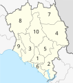
File:Amphoe Chanthaburi.svg
外观

此SVG文件的PNG预览的大小:530 × 599像素。 其他分辨率:212 × 240像素 | 424 × 480像素 | 679 × 768像素 | 905 × 1,024像素 | 1,811 × 2,048像素 | 565 × 639像素。
原始文件 (SVG文件,尺寸为565 × 639像素,文件大小:531 KB)
文件历史
点击某个日期/时间查看对应时刻的文件。
| 日期/时间 | 缩略图 | 大小 | 用户 | 备注 | |
|---|---|---|---|---|---|
| 当前 | 2014年2月10日 (一) 18:41 |  | 565 × 639(531 KB) | Potapt | More precise boundaries. |
| 2009年4月24日 (五) 13:17 |  | 565 × 639(77 KB) | Hdamm | marking Cambodia with different colour | |
| 2009年4月24日 (五) 12:41 |  | 565 × 639(83 KB) | Hdamm | {{Information |Description={{en|1=Map of Chanthaburi province, listing the districts (Amphoe) #Mueang Chanthaburi #Khlung #Tha Mai #Pong Nam Ron #Makham #Laem Sing #Soi Dao #Kaeng Hang Maeo #Na Yai Am #Khao Khitchakut}}}} |Source=Eigenes Werk ( |
文件用途
以下页面使用本文件:
全域文件用途
以下其他wiki使用此文件:
- de.wikipedia.org上的用途
- en.wikipedia.org上的用途
- ru.wikipedia.org上的用途
- th.wikipedia.org上的用途
- th.wiktionary.org上的用途
- tl.wikipedia.org上的用途
- tr.wikipedia.org上的用途

