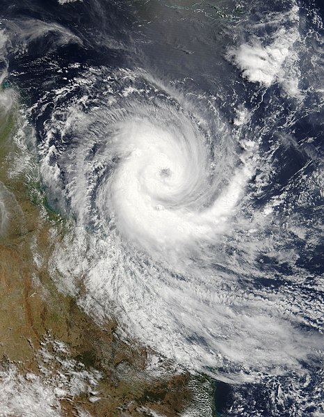
File:Cyclone Larry 19 mar 2006 0025Z.jpg
外观

本预览的尺寸:466 × 599像素。 其他分辨率:187 × 240像素 | 373 × 480像素 | 597 × 768像素 | 796 × 1,024像素 | 1,593 × 2,048像素 | 5,600 × 7,200像素。
原始文件 (5,600 × 7,200像素,文件大小:5.69 MB,MIME类型:image/jpeg)
文件历史
点击某个日期/时间查看对应时刻的文件。
| 日期/时间 | 缩略图 | 大小 | 用户 | 备注 | |
|---|---|---|---|---|---|
| 当前 | 2006年11月18日 (六) 20:29 |  | 5,600 × 7,200(5.69 MB) | Good kitty | == Summary == {{Information |Description=Tropical Cyclone Larry formed off the northeastern coast of Australia on March 18, 2006, but built strength rapidly. When the Moderate Resolution Imaging Spectroradiometer (MODIS) on the Terra satellite observed th |
文件用途
以下页面使用本文件:
全域文件用途
以下其他wiki使用此文件:
- ar.wikipedia.org上的用途
- be.wikipedia.org上的用途
- bn.wikipedia.org上的用途
- ca.wikipedia.org上的用途
- cv.wikipedia.org上的用途
- de.wikipedia.org上的用途
- en.wikipedia.org上的用途
- Coral Sea
- Wikipedia:Selected anniversaries/March 20
- Cyclone Larry
- Portal:Environment
- Portal:Tropical cyclones/Did you know/Archive
- Portal:Tropical cyclones/Anniversaries/March
- Portal:Tropical cyclones/Anniversaries/March/20
- Environmental threats to the Great Barrier Reef
- Wikipedia:Main Page history/2016 March 20
- es.wikipedia.org上的用途
- ga.wikipedia.org上的用途
- he.wikipedia.org上的用途
- krc.wikipedia.org上的用途
- mhr.wikipedia.org上的用途
- ms.wikipedia.org上的用途
- pnb.wikipedia.org上的用途
- ru.wikipedia.org上的用途
- sr.wikipedia.org上的用途
- uk.wikipedia.org上的用途
- ur.wikipedia.org上的用途


