跳转到内容

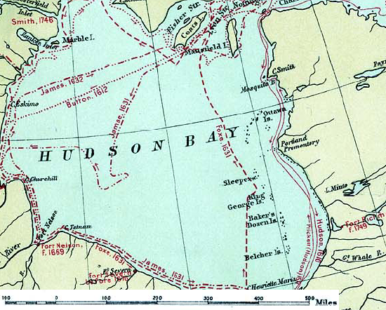
File:Hudson bay explorer.png

页面内容不支持其他语言。
这个文件来自维基共享资源
维基百科,自由的百科全书

Hudson_bay_explorer.png (550 × 442像素,文件大小:449 KB,MIME类型:image/png


描述
English: Map of the routes of the main European explorers in Hudson Bay, Canada.
日期
来源 Excerpted from 1st Edition, 1906, Atlas of Canada - Routes of Explorers,1497 to 1905.
作者 Department of the Interior, Ottawa
授权
(二次使用本文件)

Crown copyright expired.

Public domain
加拿大作品在加拿大属于public domain,因为其版权基于下列条件之一而失效︰
1. 其属于Crown copyright作品,而首次发布距今已超过50年,或

其不属于皇家版权的话:

2. 为1949年1月1日前所拍摄之照片,或
3. 作者于1972年1月1日前去世。

你必须增加美国公有领域标签显示为何这个作品在美国属于公有领域。

العربية  বাংলা  čeština  Deutsch  English  español  suomi  français  italiano  日本語  한국어  македонски  മലയാളം  Nederlands  português  português do Brasil  sicilianu  slovenščina  简体中文  繁體中文  +/−

Public domain
这个作品在美利坚合众国属于公有领域,因为它首次发布早于1929年1月1日,或于该日期之前在美国著作权局登记。

公有领域作品必须在美国以及来源国没有版权问题,才能上传至维基共享资源。如果此作品不是美国作品,这个文件必须要有一个额外的版权标记显示此文件在来源国的版权状态。
注意:此标签不应用于录音作品。PD-1923美国公有领域//commons.wikimedia.org/wiki/File:Hudson_bay_explorer.png

原始上传日志

The original description page was here. All following user names refer to en.wikipedia.
  • 2007-01-26 22:28 CyclePat 550×442×8 (459278 bytes) ==Description== This map shows the routes followed by the principal explorers of what is now Canada, from 1497 up to 1905. The map also shows the location of forts with the date of their establishment. It was created using [[:image:Canada, Routes of Explo

说明

添加一行文字以描述该文件所表现的内容

此文件中描述的项目

描绘内容

文件历史

点击某个日期/时间查看对应时刻的文件。

日期/时间缩⁠略⁠图大小用户备注
当前2008年7月10日 (四) 11:412008年7月10日 (四) 11:41版本的缩略图550 × 442(449 KB)Urdangaray{{Information |Description={{en|thumb|400px|right|Canada, Routes of Explorers,1497 to 1905 This map shows the routes followed by the principal explorers of what is now Canada, from 1497 up to 190

以下页面使用本文件:

全域文件用途

以下其他wiki使用此文件: