
File:Pakistan-Waziristan-Map.png

本预览的尺寸:606 × 599像素。 其他分辨率:243 × 240像素 | 486 × 480像素 | 700 × 692像素。
原始文件 (700 × 692像素,文件大小:96 KB,MIME类型:image/png)
摘要
| 描述 |
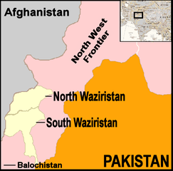
English: Map showing location of North and South Waziristan in northern Pakistan and bordering on Afghanistan |
||||
| 日期 | |||||
| 来源 | drawn by uploader using Jasc Paint Shop, using as insert map a reference map in Public Domain from the United States Central Intelligence Agency | ||||
| 作者 | Thaddeus P. Bejnar | ||||
| 授权 (二次使用本文件) |
Public Domain, I (Thaddeus P. Bejnar) hereby release this work to the Public Domain | ||||
| 其他版本 |
Note: Comments "areas of activity" means that this is not territorial control is shown.
|


.svg)


.svg)


.svg)


_Territory_Change_2014-2016.gif)

_(within_Northern_Syria).svg)


.png)
.svg)


_map.png)
.svg)


.svg)


许可协议
| 我,本作品著作权人,释出本作品至公有领域。这适用于全世界。 在一些国家这可能不合法;如果是这样的话,那么: 我无条件地授予任何人以任何目的使用本作品的权利,除非这些条件是法律规定所必需的。 |
文件历史
点击某个日期/时间查看对应时刻的文件。
| 日期/时间 | 缩略图 | 大小 | 用户 | 备注 | |
|---|---|---|---|---|---|
| 当前 | 2006年11月7日 (二) 21:59 | | 700 × 692(96 KB) | Bejnar | {{Information |Description=Map showing location of North and South Waziristan in northern Pakistan and bordering on Afghanistan |Source=drawn by uploader using Jasc Paint Shop |Date=7 November 2006 |Author=Thaddeus P. Bejnar |Permission=Public Domain, I ( |
文件用途
没有页面使用本文件。
全域文件用途
以下其他wiki使用此文件:
- ar.wikipedia.org上的用途
- ca.wikipedia.org上的用途
- cs.wikipedia.org上的用途
- cy.wikipedia.org上的用途
- de.wikinews.org上的用途
- en.wikinews.org上的用途
- 17 troops killed in bombing on Afghanistan-Pakistan border; Separate bombing kills dozens of civilians
- High level al-Qaeda leader reported dead
- Pakistani military launches ground offensive against Taliban and al-Qaeda
- Pakistan: Twelve militants killed in recent fighting
- Suspected US drone attack kills at least fourteen in Pakistan
- fr.wikipedia.org上的用途
- it.wikipedia.org上的用途
- nl.wikipedia.org上的用途
- pt.wikipedia.org上的用途
- pt.wikinews.org上的用途