
File:British National Grid.svg

此SVG文件的PNG预览的大小:204 × 377像素。 其他分辨率:130 × 240像素 | 260 × 480像素 | 415 × 768像素 | 554 × 1,024像素 | 1,108 × 2,048像素。
原始文件 (SVG文件,尺寸为204 × 377像素,文件大小:78 KB)
| 描述 |
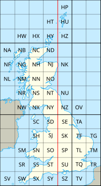
English: The en:British national grid reference system |
| 日期 | (UTC) |
| 来源 | |
| 作者 |
|
| 其他版本 |
|

本文件采用知识共享署名-相同方式共享 3.0 未本地化版本许可协议授权。
- 您可以自由地:
- 共享 – 复制、发行并传播本作品
- 修改 – 改编作品
- 惟须遵守下列条件:
- 署名 – 您必须对作品进行署名,提供授权条款的链接,并说明是否对原始内容进行了更改。您可以用任何合理的方式来署名,但不得以任何方式表明许可人认可您或您的使用。
- 相同方式共享 – 如果您再混合、转换或者基于本作品进行创作,您必须以与原先许可协议相同或相兼容的许可协议分发您贡献的作品。
原始上传日志
This image is a derivative work of the following images:
- File:National_Grid_for_Great_Britain_with_central_meridian.gif licensed with Cc-by-sa-3.0-migrated, GFDL
- 2010-02-23T23:22:36Z MansLaughter 235x434 (8630 Bytes) {{Information |Description= |Source=*[[:File:National_Grid_for_Great_Britain_with_central_meridian.png|]] |Date=2010-02-23 23:19 (UTC) |Author=*[[:File:National_Grid_for_Great_Britain_with_central_meridian.png|]]: ~~~ *deriva
- File:United_Kingdom_and_North-West_France.svg licensed with Cc-by-sa-3.0
- 2010-04-26T11:43:17Z Pethrus 270x482 (59564 Bytes) {{Information |Description={{en|Map of the United Kingdom and the North-East of France}}{{fr|Carte des îles britanniques et du Nord-Ouest de la France}} |Source=*[[:File:Europe_blank_laea_location_map.svg|]] |Date=2010-04-26
Uploaded with derivativeFX
文件历史
点击某个日期/时间查看对应时刻的文件。
| 日期/时间 | 缩略图 | 大小 | 用户 | 备注 | |
|---|---|---|---|---|---|
| 当前 | 2010年7月8日 (四) 20:06 | | 204 × 377(78 KB) | Nandhp | Remove temporary data (reference to original raster image) |
| 2010年7月8日 (四) 20:05 |  | 204 × 377(83 KB) | Nandhp | {{Information |Description={{en|The en:British national grid reference system}} |Source=*File:National_Grid_for_Great_Britain_with_central_meridian.gif *File:United_Kingdom_and_North-West_France.svg |Date=2010-07-08 20:03 (UTC) |Author=*[ |
文件用途
以下页面使用本文件:
全域文件用途
以下其他wiki使用此文件:
- de.wikipedia.org上的用途
- en.wikipedia.org上的用途
- en.wikivoyage.org上的用途
- fr.wikipedia.org上的用途
- nl.wikipedia.org上的用途
- simple.wikipedia.org上的用途