
File:C85150s1 Mount Goodale.jpg

本预览的尺寸:711 × 599像素。 其他分辨率:285 × 240像素 | 570 × 480像素 | 911 × 768像素 | 1,215 × 1,024像素 | 2,430 × 2,048像素 | 3,844 × 3,240像素。
原始文件 (3,844 × 3,240像素,文件大小:1.65 MB,MIME类型:image/jpeg)
摘要
| 描述 |
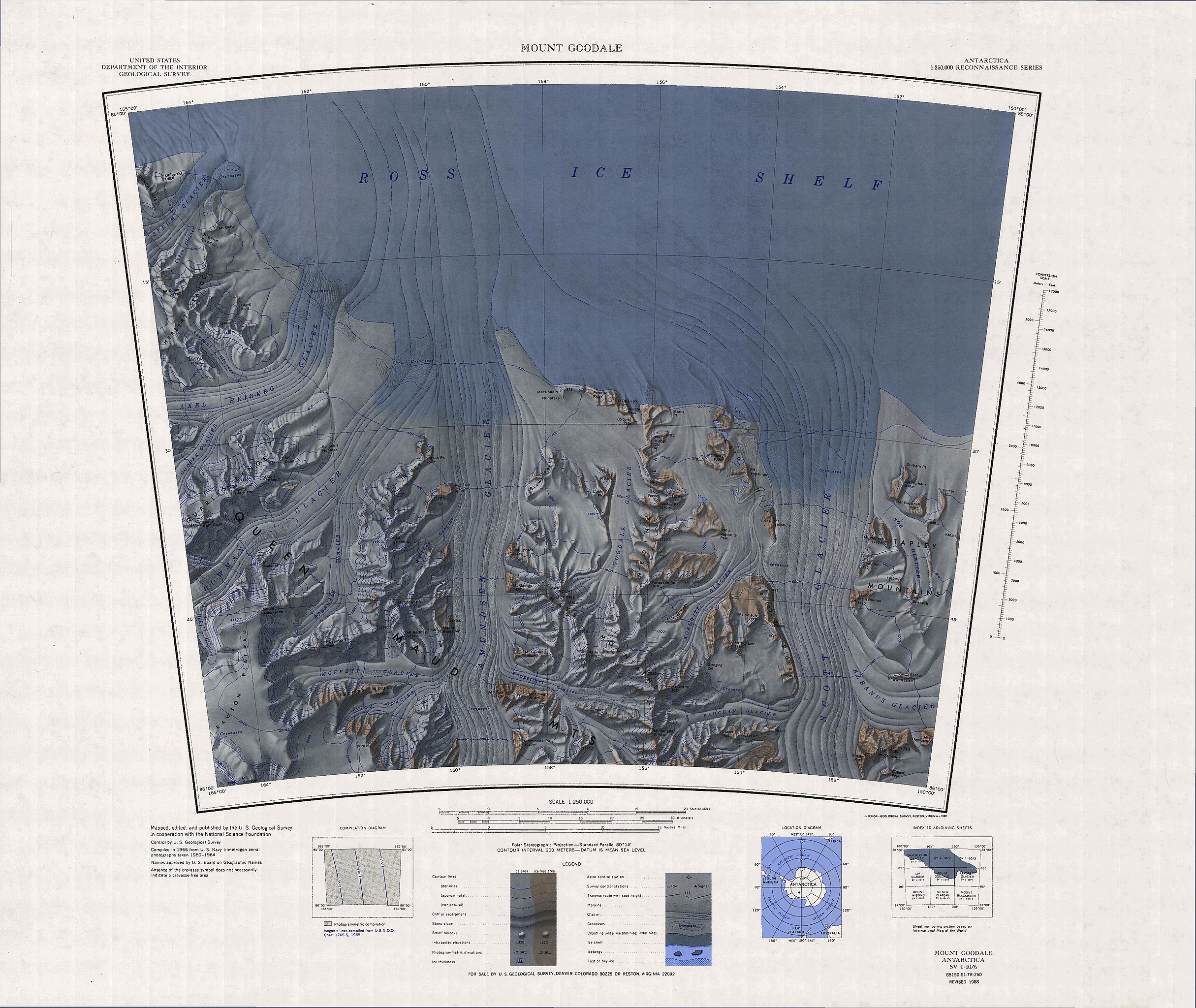
English: Topographic Reconnaissance map sheet 1:250,000 of southernmost portion of Ross Ice Shelf, Antarctica |
| 日期 | |
| 来源 | http://usarc.usgs.gov/drg_dload.shtml |
| 作者 | USGS |
许可协议
| This work is from the 美国国会图书馆. According to the library, there are no known copyright restrictions on the use of this work. |  |
文件历史
点击某个日期/时间查看对应时刻的文件。
| 日期/时间 | 缩略图 | 大小 | 用户 | 备注 | |
|---|---|---|---|---|---|
| 当前 | 2016年7月19日 (二) 15:24 | | 3,844 × 3,240(1.65 MB) | Ratzer | {{Information |Description ={{en|1=Topographic Reconnaissance map sheet 1:250,000 of southernmost portion of Ross Ice Shelf, Antarctica}} |Source =http://usarc.usgs.gov/drg_dload.shtml |Author =USGS |Date =1966 |Permission... |
文件用途
全域文件用途
以下其他wiki使用此文件:
- ar.wikipedia.org上的用途
- be.wikipedia.org上的用途
- bg.wikipedia.org上的用途
- ceb.wikipedia.org上的用途
- de.wikipedia.org上的用途
- Axel-Heiberg-Gletscher
- Herbert Range
- Watson Escarpment
- Scott-Gletscher (Marie-Byrd-Land)
- Tapley Mountains
- Amundsen-Gletscher
- MacDonald-Nunatakker
- O’Brien Peak
- Medina Peaks
- Goodale-Gletscher
- Mount Goodale
- Hays Mountains
- Mount Bushnell
- Rawson-Plateau
- Quarles Range
- Strøm-Gletscher
- Mount Betty
- Amundsen-Küste
- Karo Hills
- Mount Belecz
- Tate-Gletscher
- Thomas Spur
- Mount Dayton
- Mount Dean
- Durham Point
- Mount Durham
- Paradise Ridge
- Pincer Point
- Schobert-Nunatak
- en.wikipedia.org上的用途
查看此文件的更多全域用途。