
File:Gryka e Setës - Mapillary (8kFcRnBTxS5d7HAEDB3cjw).jpg

本预览的尺寸:800 × 444像素。 其他分辨率:320 × 178像素 | 640 × 355像素 | 1,024 × 569像素 | 1,280 × 711像素 | 1,977 × 1,098像素。
原始文件 (1,977 × 1,098像素,文件大小:424 KB,MIME类型:image/jpeg)
.jpg?uselang=zh-hans)
.jpg?uselang=zh-hans)
.jpg?action=history&uselang=zh-hans)
.jpg)
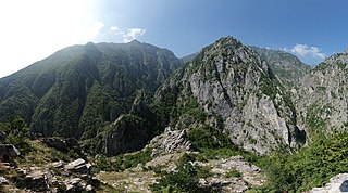
| 描述 | Gryka e Setës – canyon in Eastern Albania between Lura and Drin valley (Dibër) | ||
| 日期 | |||
| 来源 |
|
||
| 作者 | malenki @ Mapillary.com | ||
| 授权 (二次使用本文件) |
本文件采用知识共享署名-相同方式共享 4.0 国际许可协议授权。
|
| 相机位置 | | 在以下服务上查看本图像和附近其他图像: OpenStreetMap |
|---|
.jpg¶ms=041.750617_N_0020.254861_E_globe:Earth_type:camera_heading:0.00&language=zh-hans)
文件历史
点击某个日期/时间查看对应时刻的文件。
| 日期/时间 | 缩略图 | 大小 | 用户 | 备注 | |
|---|---|---|---|---|---|
| 当前 | 2018年5月2日 (三) 13:42 | | 1,977 × 1,098(424 KB) | Acabashi | Cropped 3 % horizontally, 3 % vertically using CropTool with lossless mode. Removed watermark. |
| 2016年7月9日 (六) 11:52 |  | 2,048 × 1,137(464 KB) | Albinfo | Transferred from https://d1cuyjsrcm0gby.cloudfront.net/8kFcRnBTxS5d7HAEDB3cjw/thumb-2048.jpg |
文件用途
以下页面使用本文件:
全域文件用途
以下其他wiki使用此文件:
- de.wikipedia.org上的用途
- en.wikipedia.org上的用途
.jpg)