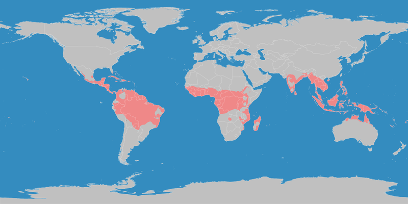
File:Klimagürtel-der-erde-tropen.png
外观

本预览的尺寸:800 × 400像素。 其他分辨率:320 × 160像素 | 640 × 320像素 | 1,024 × 512像素 | 1,280 × 640像素 | 3,600 × 1,800像素。
原始文件 (3,600 × 1,800像素,文件大小:685 KB,MIME类型:image/png)
文件历史
点击某个日期/时间查看对应时刻的文件。
| 日期/时间 | 缩略图 | 大小 | 用户 | 备注 | |
|---|---|---|---|---|---|
| 当前 | 2016年10月11日 (二) 21:13 |  | 3,600 × 1,800(685 KB) | Maphobbyist | The Caspian Sea was omitted. The Köppen system is based on the concept that climate types are correlated with the natural vegetation. |
| 2007年10月15日 (一) 15:26 |  | 3,600 × 1,800(585 KB) | Lortordermur | ||
| 2007年6月5日 (二) 20:49 |  | 3,445 × 1,731(628 KB) | Lortordermur | == Beschreibung == {{Information |Description=Diese Karte stellt die tropische Klimazone der Erde dar. |Source=Selbst erstellt auf Basis [http://www.copernicus.org/EGU/hess/hessd/4/439/hessd-4-439.htm dieser Karte], welche unter einer Creative-Commons-Li |
文件用途
以下页面使用本文件:
全域文件用途
以下其他wiki使用此文件:
- als.wikipedia.org上的用途
- de.wikiversity.org上的用途
- dsb.wikipedia.org上的用途
- en.wikipedia.org上的用途
- en.wikivoyage.org上的用途
- fy.wikipedia.org上的用途
- hsb.wikipedia.org上的用途
- ja.wikipedia.org上的用途
- ko.wikipedia.org上的用途
- mk.wikipedia.org上的用途
- nl.wikipedia.org上的用途
- ro.wikipedia.org上的用途
- sr.wikipedia.org上的用途
- sv.wikipedia.org上的用途
- tr.wikipedia.org上的用途
- vi.wikipedia.org上的用途


