
File:Old Mississippi riverbed at St. Mary.jpg

本预览的尺寸:800 × 450像素。 其他分辨率:320 × 180像素 | 640 × 360像素 | 1,024 × 576像素 | 1,280 × 720像素 | 2,816 × 1,584像素。
原始文件 (2,816 × 1,584像素,文件大小:1.87 MB,MIME类型:image/jpeg)
| 相机位置 | | 在以下服务上查看本图像和附近其他图像: OpenStreetMap |
|---|
| 描述 |
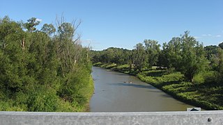
English: Looking eastward (downstream) along the old riverbed at the southern end of the causeway between Kaskaskia, Illinois and St. Mary, Missouri in the United States. Until a catastrophic shift in 1881, this small stream was the Mississippi River. |
||
| 日期 | 摄于2012年9月8日 | ||
| 来源 | 自己的作品 | ||
| 作者 | Nyttend | ||
| 授权 (二次使用本文件) |
|
文件历史
点击某个日期/时间查看对应时刻的文件。
| 日期/时间 | 缩略图 | 大小 | 用户 | 备注 | |
|---|---|---|---|---|---|
| 当前 | 2012年9月24日 (一) 04:01 | | 2,816 × 1,584(1.87 MB) | Nyttend | {{Location|37|52|48|N|89|56|53|W}} {{Information |Description={{en|Looking eastward (downstream) along the old riverbed at the southern end of the causeway between {{w|Kaskaskia, Illinois|Kaskaskia}}, {{w|Illinois}} and {{w|St. Mary, Missouri|St. Mary}... |
文件用途
以下页面使用本文件:
全域文件用途
以下其他wiki使用此文件:
- ar.wikipedia.org上的用途
- azb.wikipedia.org上的用途
- ca.wikipedia.org上的用途
- ceb.wikipedia.org上的用途
- ce.wikipedia.org上的用途
- cy.wikipedia.org上的用途
- en.wikipedia.org上的用途
- es.wikipedia.org上的用途
- eu.wikipedia.org上的用途
- fa.wikipedia.org上的用途
- ht.wikipedia.org上的用途
- it.wikipedia.org上的用途
- lld.wikipedia.org上的用途
- pl.wikipedia.org上的用途
- pt.wikipedia.org上的用途
- sh.wikipedia.org上的用途
- sr.wikipedia.org上的用途
- sv.wikipedia.org上的用途
- tt.wikipedia.org上的用途
- uk.wikipedia.org上的用途
- ur.wikipedia.org上的用途
- uz.wikipedia.org上的用途
- www.wikidata.org上的用途
- zh-min-nan.wikipedia.org上的用途