
File:Parinacota Volcano, South America.JPG

本预览的尺寸:800 × 531像素。 其他分辨率:320 × 213像素 | 640 × 425像素 | 1,024 × 680像素 | 1,280 × 850像素 | 2,560 × 1,700像素 | 4,288 × 2,848像素。
原始文件 (4,288 × 2,848像素,文件大小:10.67 MB,MIME类型:image/jpeg)
摘要
| 描述 |
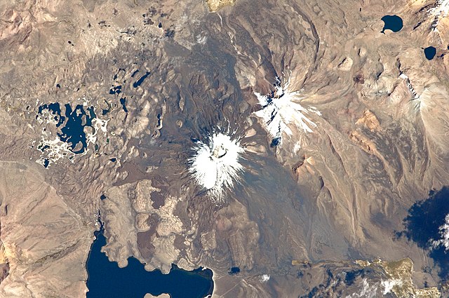
English: This astronaut photograph from the International Space Station highlights the symmetrical cone of Parinacota, with its well-developed summit crater (elevation 6,348 meters above sea level). Dark brown to dark gray surfaces to the east and west of the summit include lava flows, pyroclastic deposits, and ash.
A companion volcano, Pomerape, is located across a low saddle to the north. This volcano last erupted during the Pleistocene Epoch (approximately 3 million to 12,000 years ago). Together, Parinacota and Pomerape form the Nevados de Payachata volcanic area. The summits of both volcanoes are covered by white snowpack and small glaciers. Eruptive activity at Parinacota has directly influenced development of the local landscape, beyond the placement of volcanic deposits. Approximately 8,000 years ago, the western flank of the volcano collapsed, creating a debris avalanche that travelled 22 kilometres to the west. The debris blocked rivers and streams, leading to the formation of Chungará Lake to the south (lower left). The uneven, hummocky surface of the avalanche debris provides ample catchments for water, as evidenced by the numerous small ponds and Cotacotani Lake to the west. |
| 日期 | |
| 来源 | NASA Earth Observatory |
| 作者 | ISS Expedition 29 crew |
| 相机位置 | | 在以下服务上查看本图像和附近其他图像: OpenStreetMap |
|---|
本图像或视频收录于美国国家航空航天局 (NASA)休斯顿太空中心(Johnson Space Center),其照片编号是: ISS029-E-20003 此标签不表示文件的著作权状态。任何文件在附有此标签的同時还需要一个有效的著作权标签。请参阅许可协议说明页面以了解更多信息。 其他语言:
|
Image acquired with a Nikon D2Xs digital camera using a 400 mm lens, and is provided by the ISS Crew Earth Observations experiment and Image Science & Analysis Laboratory, Johnson Space Center.
许可协议
| 本文件完全由NASA创作,在美国属于公有领域。根据NASA的版权方针,NASA的材料除非另有声明否则不受版权保护。(参见Template:PD-USGov/zh、NASA版权方针页面或JPL图片使用方针。) | ||
 |
警告:
|
| 注解 | 该图片含有注解:在维基媒体共享资源上查看注解 |
文件历史
点击某个日期/时间查看对应时刻的文件。
| 日期/时间 | 缩略图 | 大小 | 用户 | 备注 | |
|---|---|---|---|---|---|
| 当前 | 2011年10月17日 (一) 13:26 | | 4,288 × 2,848(10.67 MB) | Originalwana | {{Information |Description ={{en|1=This astronaut photograph from the International Space Station highlights the symmetrical cone of Parinacota, with its well-developed summit crater (elevation 6,348 meters above sea level). Dark brown to dark |
文件用途
全域文件用途
以下其他wiki使用此文件:
- bs.wikipedia.org上的用途
- en.wikipedia.org上的用途
- ja.wikipedia.org上的用途
- lld.wikipedia.org上的用途
- www.wikidata.org上的用途