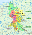
File:Weser Einzugsgebiet+Nr.png
外观

本预览的尺寸:535 × 599像素。 其他分辨率:214 × 240像素 | 428 × 480像素 | 791 × 886像素。
原始文件 (791 × 886像素,文件大小:189 KB,MIME类型:image/png)
文件历史
点击某个日期/时间查看对应时刻的文件。
| 日期/时间 | 缩略图 | 大小 | 用户 | 备注 | |
|---|---|---|---|---|---|
| 当前 | 2017年2月7日 (二) 09:04 |  | 791 × 886(189 KB) | Ulamm | more suggestive colour code |
| 2017年2月5日 (日) 20:05 |  | 791 × 886(190 KB) | Ulamm | some landscapes | |
| 2017年2月5日 (日) 19:18 |  | 791 × 886(186 KB) | Ulamm | three more names | |
| 2017年2月5日 (日) 18:40 |  | 791 × 886(184 KB) | Ulamm | that had not been the last version | |
| 2017年2月5日 (日) 18:39 |  | 791 × 886(468 KB) | Ulamm | == {{int:filedesc}} == {{Information |Description= {{de|Einzugsgebiet der Weser mit Teileinzugsgebieten}} {{en|Drainage basin of Weser River with partitions}} |Source=File:Weser Einzugsgebiet.png * GTOPO-30 Eleva... |
文件用途
以下页面使用本文件:
全域文件用途
以下其他wiki使用此文件:
- azb.wikipedia.org上的用途
- de.wikipedia.org上的用途
- mg.wikipedia.org上的用途
- nl.wikipedia.org上的用途
- no.wikipedia.org上的用途
- sv.wikipedia.org上的用途


