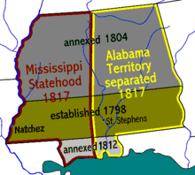
阿拉巴馬領地
外觀
| 阿拉巴馬領地 Territory of Alabama | |||||||||
|---|---|---|---|---|---|---|---|---|---|
| 美國的合併建制領土 | |||||||||
| 1817年—1819年 | |||||||||
|
旗幟 | |||||||||
 | |||||||||
| 坐標:32°39′28″N 86°47′31″W / 32.657875°N 86.791991666667°W | |||||||||
| 國家 | 美國 | ||||||||
| 首府 | 聖斯蒂芬斯 | ||||||||
| 政府 | |||||||||
| • 類型 | 合併建制領土 | ||||||||
| 總督 | |||||||||
• 1817-1819 | 威廉·懷亞特·比布 | ||||||||
| 歷史 | |||||||||
• 成立 | 1817年12月10日[1] | ||||||||
• 建州 | 1819年12月14日[1] | ||||||||
| |||||||||
阿拉巴馬領地(英語:Alabama Territory)是美國歷史上的一個合併建制領土[2][3],存在於1817年8月15日至1819年12月14日之間,之後升格為美國第22個州阿拉巴馬州[4]。阿拉巴馬領地系自密西西比領地分裂產生。
參考文獻
[編輯]- ^ 1.0 1.1 "An 1820 Claim to Congress: Alabama Territory: 1817"; The Intruders; TNGenNet Inc.; 2001; quick webpage: TN-537 (頁面存檔備份,存於網際網路檔案館)
- ^ "An Act to enable the people of the western part of the Mississippi territory to form a constitution and state government, and for the admission of such state into the union, on an equal footing with the original state". [2020-09-21]. (原始內容存檔於2020-04-07).
- ^ "An Act to establish a separate territorial government for the eastern part of the Mississippi territory". [2020-09-21]. (原始內容存檔於2020-04-07).
- ^ "Resolution declaring the admission of the state of Alabama into the Union". [2020-09-21]. (原始內容存檔於2020-04-07).
- Williams, Lewis et al.; "An 1820 Claim to Congress: Alabama Territory : 1817." (頁面存檔備份,存於網際網路檔案館) Op. cit.: Gales & Seaton; American State Papers';' Washington: 1834; retrieved 21 February 2010.
| 這是一篇與美國地理相關的小作品。您可以透過編輯或修訂擴充其內容。 |

