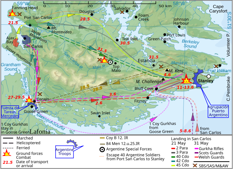
File:Land.ops.2.en.svg
外觀

此 SVG 檔案的 PNG 預覽的大小:800 × 581 像素。 其他解析度:320 × 233 像素 | 640 × 465 像素 | 1,024 × 744 像素 | 1,280 × 930 像素 | 2,560 × 1,860 像素 | 940 × 683 像素。
原始檔案 (SVG 檔案,表面大小:940 × 683 像素,檔案大小:1.42 MB)
檔案歷史
點選日期/時間以檢視該時間的檔案版本。
| 日期/時間 | 縮圖 | 尺寸 | 使用者 | 備註 | |
|---|---|---|---|---|---|
| 目前 | 2012年3月26日 (一) 10:40 |  | 940 × 683(1.42 MB) | Brammers | Spelling change: Marsh > Marched |
| 2010年11月1日 (一) 19:47 |  | 940 × 683(1.42 MB) | Keysanger | {{Information |Description={{en|The '''Falkland Islands''' are an archipelago in the South Atlantic Ocean}} |Source=*File:Falkland_Islands_topographic_map-en.svg |Date=2010-11-01 19:44 (UTC) |Author=*[[:File:Falkland_Islands_topographic_map-en.s |
檔案用途
下列頁面有用到此檔案:
全域檔案使用狀況
以下其他 wiki 使用了這個檔案:
- en.wikipedia.org 的使用狀況
- fy.wikipedia.org 的使用狀況
- he.wikipedia.org 的使用狀況
- lt.wikipedia.org 的使用狀況
- pl.wikipedia.org 的使用狀況
- ro.wikipedia.org 的使用狀況
- ru.wikipedia.org 的使用狀況


