
File:Map of the Samanid amirate at the death of Nasr II, 943.svg

此 SVG 檔案的 PNG 預覽的大小:800 × 562 像素。 其他解析度:320 × 225 像素 | 640 × 450 像素 | 1,024 × 720 像素 | 1,280 × 900 像素 | 2,560 × 1,800 像素 | 1,603 × 1,127 像素。
原始檔案 (SVG 檔案,表面大小:1,603 × 1,127 像素,檔案大小:6.95 MB)
摘要
| 描述 |
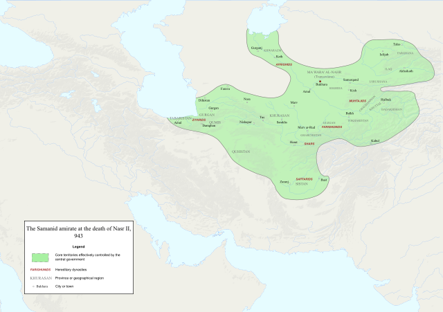
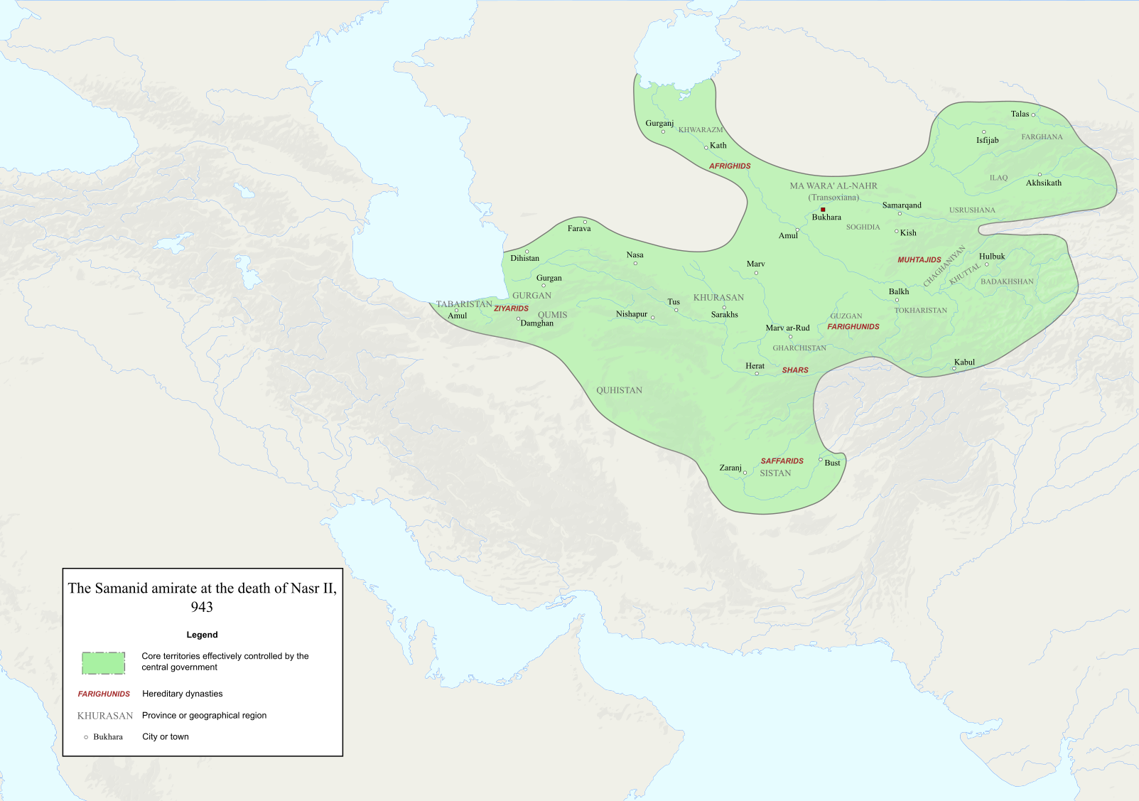
English: Map of the Samanid amirate at the death of Nasr II. |
| 來源 |
Map is mainly based on two maps of mid 10th-century Central Asia under the Samanids in the pages 23 and 25 of An Historical Atlas of Central Asia, written by Yuri Bregel and published by Brill, supplied by NAṢR (I) B. AḤMAD (I) B. ESMĀʿIL [1] and Frye, R. N. (1975). "The Sāmānids". In Frye, Richard N. (ed.). The Cambridge History of Iran, Volume 4: From the Arab Invasion to the Saljuqs. Cambridge: Cambridge University Press. pp. 136–161. Since the maps in the source "only" showed Central Asia, I was missing very few parts of the southern border of the Samanids, which I used the following sources to construct;
|
| 作者 | Original file by Ro4444, edited by me |
| 授權許可 (重用此檔案) |
File:Abbasid_Caliphate_891-892.png |
授權條款
我,本作品的著作權持有者,決定用以下授權條款發佈本作品:

|
已授權您依據自由軟體基金會發行的無固定段落、封面文字和封底文字GNU自由文件授權條款1.2版或任意後續版本,對本檔進行複製、傳播和/或修改。該協議的副本列在GNU自由文件授權條款中。 |
此檔案採用創用CC 姓名標示-相同方式分享 4.0 國際授權條款。
- 您可以自由:
- 分享 – 複製、發佈和傳播本作品
- 重新修改 – 創作演繹作品
- 惟需遵照下列條件:
- 姓名標示 – 您必須指名出正確的製作者,和提供授權條款的連結,以及表示是否有對內容上做出變更。您可以用任何合理的方式來行動,但不得以任何方式表明授權條款是對您許可或是由您所使用。
- 相同方式分享 – 如果您利用本素材進行再混合、轉換或創作,您必須基於如同原先的相同或兼容的條款,來分布您的貢獻成品。
您可以選擇您需要的授權條款。
檔案歷史
點選日期/時間以檢視該時間的檔案版本。
| 日期/時間 | 縮圖 | 尺寸 | 使用者 | 備註 | |
|---|---|---|---|---|---|
| 目前 | 2022年12月3日 (六) 14:06 | | 1,603 × 1,127(6.95 MB) | HistoryofIran | ditto |
| 2022年12月3日 (六) 14:02 |  | 1,603 × 1,127(6.95 MB) | HistoryofIran | several adjustments | |
| 2020年10月3日 (六) 02:22 |  | 1,603 × 1,127(6.91 MB) | HistoryofIran | removed banijurids, didnt rule back then | |
| 2020年10月3日 (六) 02:19 |  | 1,603 × 1,127(6.92 MB) | HistoryofIran | banijurids | |
| 2020年10月2日 (五) 16:32 |  | 1,603 × 1,127(6.92 MB) | HistoryofIran | moved Soghdia a bit more west | |
| 2020年10月2日 (五) 16:28 |  | 1,603 × 1,127(6.92 MB) | HistoryofIran | Ghur | |
| 2020年10月2日 (五) 16:22 |  | 1,603 × 1,127(6.92 MB) | HistoryofIran | small fix | |
| 2020年10月2日 (五) 15:02 |  | 1,603 × 1,127(6.94 MB) | HistoryofIran | under Nasr II | |
| 2020年10月2日 (五) 13:16 |  | 1,603 × 1,127(6.93 MB) | HistoryofIran | added capital dot, fixed border in tabaristan | |
| 2020年10月2日 (五) 04:23 |  | 1,603 × 1,127(6.92 MB) | HistoryofIran | {{subst:Upload marker added by en.wp UW}} {{Information |Description = {{en|Map of the traditional domain of the Samanids.}} |Source = Cambridge History of Iran vol 4, Iranica, etc. Might add a more detailed list in the future. |Author = Original file by Ro4444, edited by me |Permission = File:Abbasid_Caliphate_891-892.png }} |
檔案用途
下列頁面有用到此檔案:
全域檔案使用狀況
以下其他 wiki 使用了這個檔案:
- az.wikipedia.org 的使用狀況
- en.wikipedia.org 的使用狀況
- id.wikipedia.org 的使用狀況
- it.wikipedia.org 的使用狀況
- ky.wikipedia.org 的使用狀況
- lt.wikipedia.org 的使用狀況
- mg.wikipedia.org 的使用狀況
- pl.wikipedia.org 的使用狀況
- ps.wikipedia.org 的使用狀況
- ru.wikipedia.org 的使用狀況
- ta.wikipedia.org 的使用狀況
- tr.wikipedia.org 的使用狀況
- uz.wikipedia.org 的使用狀況