
File:Sutherland Flow Country.jpg
無更高解析度可提供。
Sutherland_Flow_Country.jpg (640 × 480 像素,檔案大小:59 KB,MIME 類型:image/jpeg)
| 描述 |
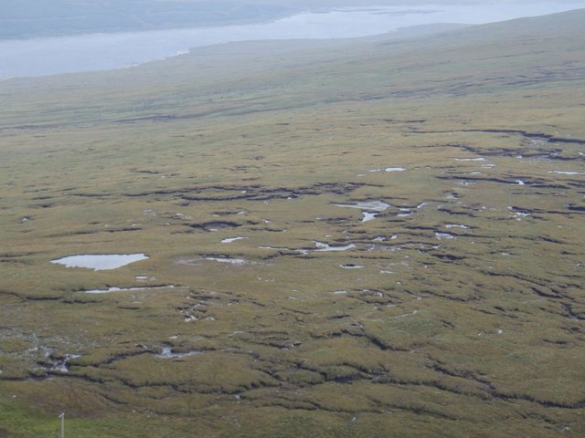
English: The en:Flow Country in en:Sutherland. A very small part of the 4000 sq km blanket bog in Sutherland and Caithness taken from near the top of Maovally. The drizzle encourages the feeling of total saturation! The lochans seems to follow the line of the watershed. The ridges seem to be bog "stretch marks" as it flows down the slope in the foreground to Glen Cassley and in the background to Loch Shin. |
| 日期 | |
| 來源 | From geograph.org.uk |
| 作者 | Graeme Smith |
| 授權許可 (重用此檔案) |
Creative Commons Attribution Share-alike license 2.0 |
| 姓名標示 (由许可协议要求) | Graeme Smith / Sutherland Flow Country / |
| 拍攝地點 | | 位於此地的本圖片與其他圖片: OpenStreetMap |
|---|

|
此檔案採用創用CC 姓名標示-相同方式分享 2.0 通用版授權條款。
姓名標示: Graeme Smith
- 您可以自由:
- 分享 – 複製、發佈和傳播本作品
- 重新修改 – 創作演繹作品
- 惟需遵照下列條件:
- 姓名標示 – 您必須指名出正確的製作者,和提供授權條款的連結,以及表示是否有對內容上做出變更。您可以用任何合理的方式來行動,但不得以任何方式表明授權條款是對您許可或是由您所使用。
- 相同方式分享 – 如果您利用本素材進行再混合、轉換或創作,您必須基於如同原先的相同或兼容的條款,來分布您的貢獻成品。
檔案歷史
點選日期/時間以檢視該時間的檔案版本。
| 日期/時間 | 縮圖 | 尺寸 | 使用者 | 備註 | |
|---|---|---|---|---|---|
| 目前 | 2008年10月14日 (二) 11:14 | | 640 × 480(59 KB) | Angusmclellan | {{Information |Description={{en|The en:Flow Country in en:Sutherland. A very small part of the 4000 sq km blanket bog in Sutherland and Caithness taken from near the top of Maovally. The drizzle encourages the feeling of total saturation! The lo |
檔案用途
下列頁面有用到此檔案:
全域檔案使用狀況
以下其他 wiki 使用了這個檔案:
- ar.wikipedia.org 的使用狀況
- de.wikipedia.org 的使用狀況
- en.wikipedia.org 的使用狀況
- en.wikivoyage.org 的使用狀況
- es.wikipedia.org 的使用狀況
- fr.wikipedia.org 的使用狀況
- hy.wikipedia.org 的使用狀況
- it.wikipedia.org 的使用狀況
- kk.wikipedia.org 的使用狀況
- lv.wikipedia.org 的使用狀況
- mt.wikipedia.org 的使用狀況
- nl.wikipedia.org 的使用狀況
- ru.wikipedia.org 的使用狀況
- simple.wikipedia.org 的使用狀況
- sl.wikipedia.org 的使用狀況
- uk.wikipedia.org 的使用狀況
- vi.wikipedia.org 的使用狀況
- www.wikidata.org 的使用狀況